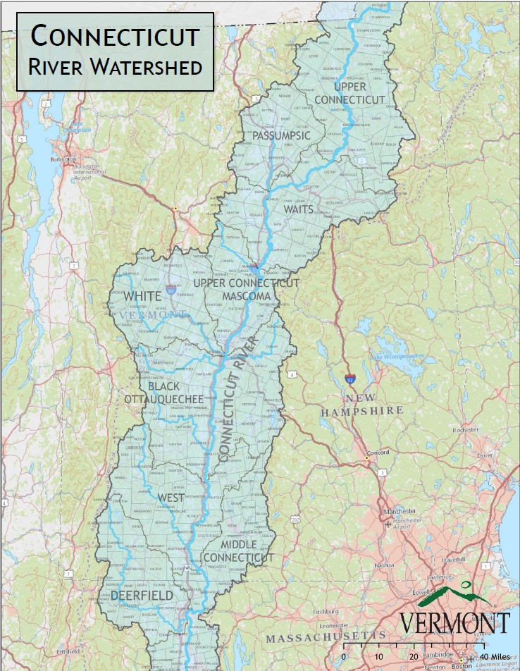
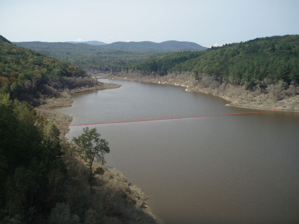
The Connecticut River, originally quinetucket and kwinitekw, “long tidal river,” is the longest river in New England. Its 11,260 square mile watershed encompasses parts of five states and the Province of Quebec. The river is fed by 148 tributaries including 38 major rivers along its path. It is home to over 2.4 million people. The Connecticut River was the first river designated as an American Heritage River, and it is the first, and only, National Blueway in the country.
The Connecticut River forms the border between Vermont and New Hampshire, traverses the center of Massachusetts and Connecticut and meets the Atlantic Ocean in Long Island Sound. The VT/NH state line was set in 1934 as the low water mark on the Vermont side. This was prior to the large hydro-electric dams being built. Due to the widening of the channel behind these dams, along its course Vermont’s border varies from right at the shoreline to over 500 feet into the present river.
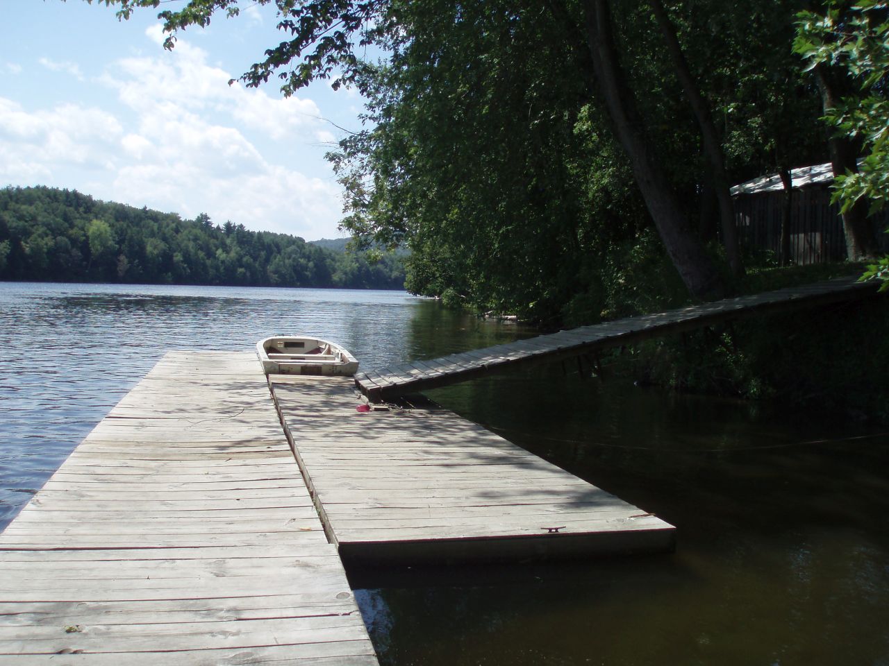
Referred to at times, as “the world’s most beautifully landscaped cesspool” and “the great main street of New England,” the Connecticut River has a long history of human use and abuse. Decades of work, financial investment and dedicated residents have transformed the river into a recreational resource, a drinking water supply for millions, an economic driver and a 410 mile long natural treasure.
Information on restoration priorities and clean water project implementation in the Connecticut River basin in Vermont can be found on the following tactical basin planning webpages:
- Basin 9 - White
- Basin 10 - Ottauquechee, Black
- Basin 11 - West, Williams, Saxtons, Connecticut Direct
- Basin 12 & 13 - Deerfield, Connecticut Direct
- Basin 14 - Stevens, Wells, Waits, Ompompanoosuc, Connecticut Direct
- Basin 15 - Passumpsic
- Basin 16 - Upper Connecticut
TMDL
The Long Island Sound TMDL for the Connecticut River identifies an overabundance of nitrogen as the cause of hypoxia, or low levels of dissolved oxygen, in Long Island Sound. While nitrogen is essential to a productive ecosystem, too much nitrogen fuels the excessive growth of algae. When the algae die, they sink to the bottom, where they are consumed by bacteria. The microbial decay of algae and the respiration of oxygen-breathing organisms use up the available oxygen in the lower water column and in the bottom sediments, gradually reducing the dissolved oxygen concentration to unhealthy levels.
Long Island Sound TMDL Enhanced Implementation Plan Report: 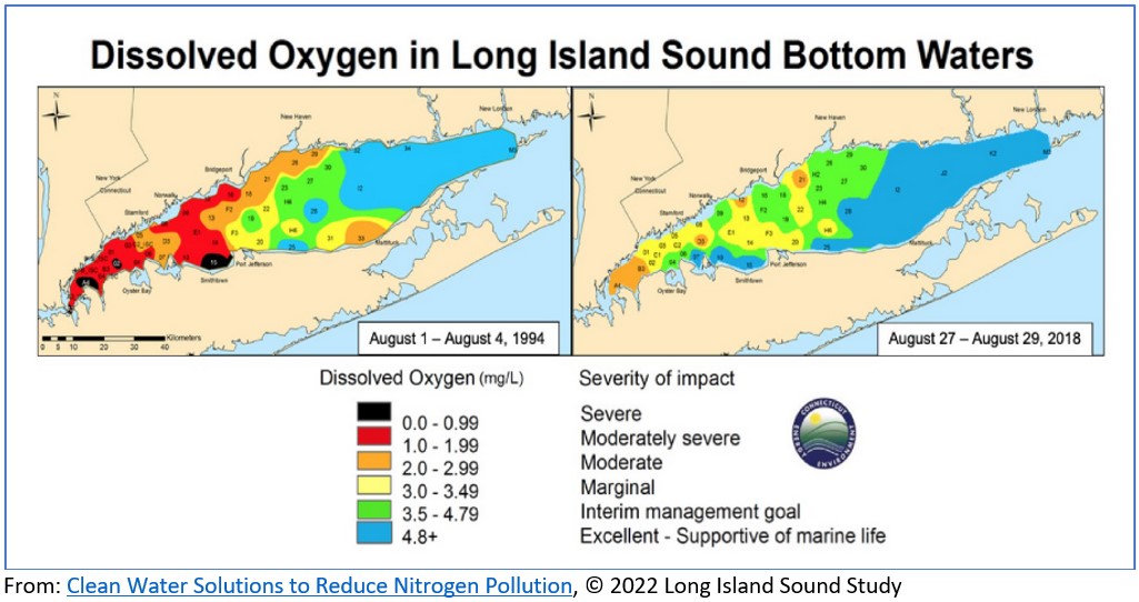
• Long Island Sound Nitrogen TMDL, NEIWPCC
• Vermont State Section prepared by VTDEC
• New Hampshire State Section prepared by NH DES
• Long Island Sound Study
Hydroelectric Production
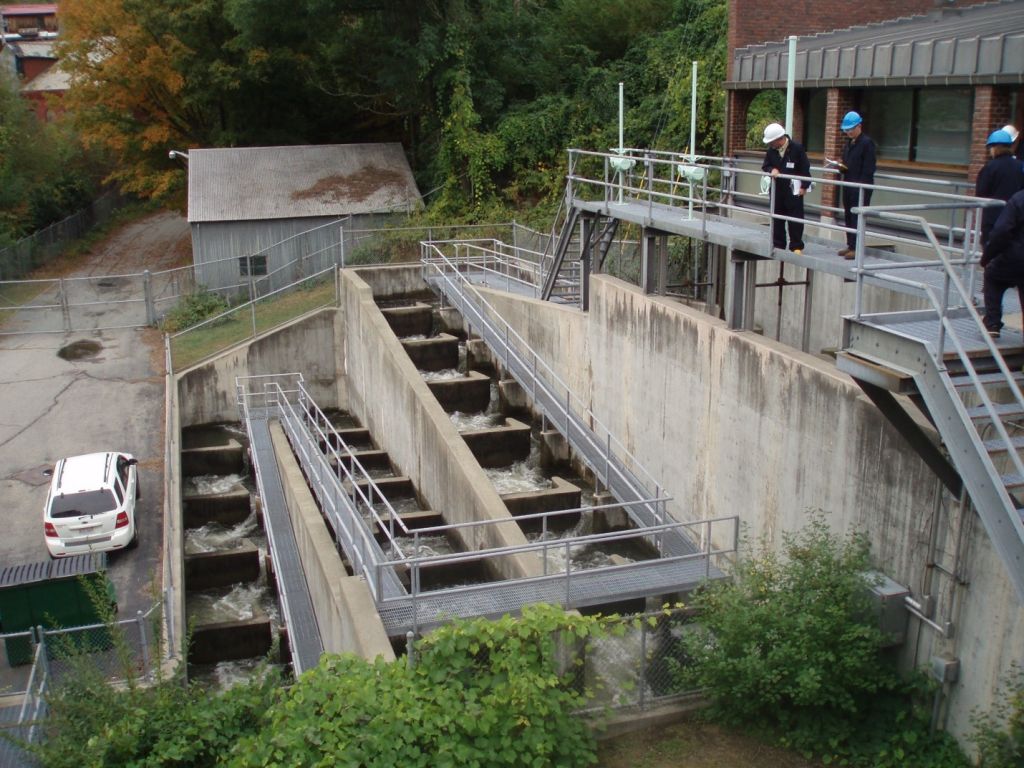
The Connecticut River between Vermont and New Hampshire is spanned by a series of hydroelectric production dams generating 474 MW of electricity annually. The Federal Regulatory Energy Commission licenses and relicenses these dams every 40 – 50 years.
• Canaan
• Gilman
• Moore Station Dam
• Comerford Dam
• McIndoes Falls
• Wilder Dam Hydro Project
• Bellows Falls Dam
• Vernon Dam
Three additional dams are downstream in Massachusetts:
• Turners Falls Dam
• Northfield Mountain
• Holyoke Dam
Flood Control:
There are 14 U.S. Army Corps of Engineers dams on nine Connecticut River tributaries across four states (Connecticut River Sustainable Rivers Program). The Reservoir Control Center (RCC), located at the Corps' New England District Headquarters in Concord, MA, is the "nerve center" for all Corps-operated dams in New England. Using radio and satellite communications, RCC constantly monitors river levels and weather conditions and directs the operation of the dams during high flows. For information on river flows, dam operations, snow depths, recreational water releases and more visit the RCC home page.
The Vermont/New Hampshire dams include:
• Townshend Lake Dam, Townshend
• Ball Mountain Lake Dam, Jamaica
• North Springfield Dam, Springfield
Stoughton Pond Dam – recreational lake
• North Hartland Lake Dam, Hartland
• Union Village Dam, Thetford
• Otter Brook Dam, Keene, NH
• Surry Mountain Dam, Surry, NH
Cumulatively these dams are estimated to have prevented $785.1 million in flood damages to down-river communities while also offering a variety of recreational opportunities.
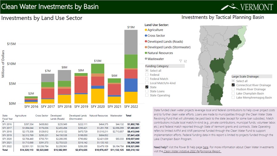
Vermont’s Clean Water Investment:
Since 2016 the State of Vermont has invested over $60 million dollars in water quality improvement projects in the Connecticut River watershed. This State investment has leveraged Federal, local and private funds resulting in over $126 million dollars of grants, loans and match funds for clean water efforts.
Reports:
USFWS Connecticut River Basin Annual Report – 2021, Ken Sprankle, Project Leader, Federal Aid Project # F-100-R-38
The Value of The Connecticut River: A Cost-Benefit Analysis of Vermont Clean Water Act Spending, Presented to the Committee on Natural Resources, Fish and Wildlife, Vermont House of Representatives
PRS Policy Brief 1617-06, April 13, 2017
Connecticut River Flow Restoration Study, The Nature Conservancy and the U.S. Army Corps of Engineers (USACE), 2018
Connecticut River Fish Tissue Contaminant Study: Ecological and Human Health Risk Screening,
US EPA, 2006
Pamela D. Hunt, Michael Blust, and Fred Morrison, Lotic Odonata of the Connecticut River in New Hampshire and Vermont, Naturalist 17(2), 175-188, (1 June 2010). https://doi.org/10.1656/045.017.0201
Freshwater Mussel Survey in the Connecticut River for the Vernon, Bellows Falls, and Wilder Hydroelectric Projects, FERC PROJECT #1889, 2485, Biodrawversity, Amherst, MA, 2012
Resources:
Vermont Integrated Watershed Information System (IWIS) VTDEC-Watershed Management Division’s online data portal for water quality information.
Clean Water Portal access to VT ANR Clean Water databases including:
- Clean Water Project Explorer an interactive map application that provides geographically search for clean water projects.
- Watershed Projects Database a publicly accessible search interface for the Watershed Project Database (WPD), including Clean Water Initiative Program funded projects, potential projects identified though Tactical Basin Planning.
Is It Clean? Interactive maps shows bacteria levels for each sampling date and also whether or not it was a wet weather event. Covers VT, NH, MA and CT.
SPARROW: Models for the Northeast: Total Phosphorus, Total Nitrogen, Suspended Sediment, and Streamflow (USGS)
Related Sites:
Connecticut River, The Trust for Public Land
Connecticut River National Blueway, US Fish and Wildlife Service
Connect the Connecticut, The North Atlantic Landscape Conservation Cooperative, offers a landscape conservation design approach uses geospatial data, biological information, and models to identify opportunities to protect species, habitats, and environmental processes across an entire landscape
Connecticut River Paddlers Trail, a series of primitive campsites and river access points spanning from the headwaters south to long island sound.
Cooperative Invasive Species Management Area
- Upper Connecticut River Watershed CISMA, an Invasive Species Management Partnership for the Upper Connecticut Watershed
- Southeast Vermont CISMA,
Silvio O. Conte National Fish and Wildlife Refuge was established in 1997 to conserve, protect and enhance the abundance and diversity of native plant, fish and wildlife species and the ecosystems on which they depend throughout the 7.2 million acre Connecticut River watershed.
Connecticut River Fish and Wildlife Conservation Office, US Fish & Wildlife Service, whose mission is conserving and restoring migratory fish and resident aquatic species in the Connecticut River basin, and protecting the lakes, rivers, and wetlands where they live.
Connecticut River Byway – VT, designated as a National Scenic Byway for both its scenic and historic qualities that it has as it goes up the State. The landscape of the Byway centers on the Connecticut River and includes the neighboring farmlands, floodplains, step-like terraces, and the slopes of the bordering uplands. The river and surrounding landscape provide rich recreational opportunities.
State of Vermont Funding Opportunities:
Agency of Natural Resources
Department of Environmental Conservation - Water Investment Division
• Clean Water Initiative - Funding Opportunities
• Water Infrastructure Financing Programs
Agency of Agriculture, Food & Markets
• Assistance Programs
Agency of Transportation
• Municipal Highway and Stormwater Mitigation Program
Vermont Housing and Conservation Board
• Water Quality Grants
Partners:
• NH DES Rivers Management and Protection Program
• MA DEP Watershed Planning Program
• Connecticut River Conservancy (CRC)
• Connecticut River Joint Commissions (CRJC)
• Connecticut River Watershed Farmers Alliance (CRWFA)
• Windham County Natural Resources Conservation District (WCNRCD)
• Ottauquechee Natural Resources Conservation District (ONRCD)
• White River Natural Resources Conservation District (WRNRCD)
• Caledonia County Natural Resources Conservation District (CCNRCD)
• Essex County Natural Resources Conservation District (ECNRCD)
• Windham Regional Commission (WRC)
• Mount Ascutney Regional Commission (MARC)
• Two-River Ottauquechee Regional Commission (TRORC)
• Central Vermont Regional Planning Commission (CVRPC)
• Northeastern Vermont Development Association (NVDA)
• Upper Valley Lake Sunapee Regional Planning Commission (UVLSRPC)
Get Involved:
Watershed Groups and Volunteer Monitoring
• Passumpsic Valley Land Trust
• White River Partnership
• Black River Action Team (BRAT)
• Lake Raponda Association, Inc.
• Lake Rescue Association, Inc.
• Maidstone Lake Association
• Ticklenaked Pond Association
• Lake Fairlee Association
• Lake Morey Protective Association