What's New?
The 2024 Deerfield Tactical Basin Plan is ready to implement!
Read the 2024 Deerfield Tactical Basin Plan.
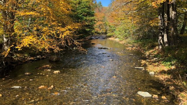
The 2024 Plan is a five-year update of the Deerfield River watershed and the Connecticut River tributaries in southeastern Vermont. The 2024 Plan describes the water quality and habitat conditions and lays out strategies and actions recommended for implementation over the coming years.
The 77 actions identified in the Plan will protect or improve rivers, lakes, and wetlands through cost-effective projects, including floodplain restorations, dam removals and other types of projects in all land use sectors including agriculture, developed lands, wastewater and natural resources. Additionally, this Plan offers strategies to address climate change adaptation and social equity concerns.
Over 130 projects are identified in the Watershed Projects Database and can be found in the Clean Water Project Explorer, an on-line interactive map showing the projects and locations.
Funding is available to implement these projects through state and federal programs. The participation of willing landowners across the Basin is needed to allow these projects to be implemented. Landowners and others interested in participating can contact:
Marie Levesque Caduto, Watershed Coordinator
Vermont ANR / Department of Environmental Conservation
100 Mineral Street, Suite 303
Springfield, VT 05156-3168
Phone: 802-490-6142
Email: Marie.Caduto@vermont.gov
Learn more about the Basin in the Deerfield River StoryMap.
Two public meetings were held to discuss the DRAFT Water Quality Plan in October 2024 hosted by State and regional planners. Recordings of these meetings can be viewed.
October 15, 2024 Brattleboro, VT
October 17, 2024 Wilmington, VT
This basin plan provides an overall assessment of the current conditions of the watershed, identifies high priority waters for restoration and protection, and directs funding to implement projects that protect, enhance, and restore aquatic habitat that supports the uses and values such as swimming, fishing, and boating.
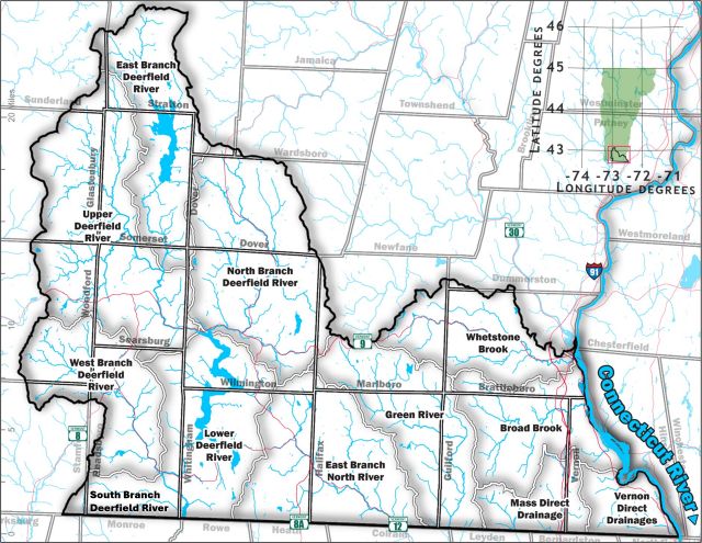
Basin 12 includes 18 towns including Brattleboro, Dover, Stratton, and Wilmington. It encompasses the Deerfield and Green Rivers and the East Branch of the North River which all flow into central Massachusetts to the Connecticut River. The tributary streams that flow directly into the Connecticut River include Whetstone, Broad and Newton Brooks.
2020 Tactical Basin Plan
2014 Tactical Basin Plan and Appendices
Basin Assessment Report Basin 12 - Deerfield River and Connecticut River Direct (June 2023)
Additional Resources
- Existing Uses - Basin 12
- Illicit Discharge Detection and Elimination in Brattleboro, FINAL REPORT (January, 2012)
- Basin 12 Water Quality and Aquatic Habitat Updated Assessment Report
- Basin 13 - Lower Connecticut River Direct Drainage Assessment Report (April 2002)
- Crosby Brook Stream Corridor Restoration Plan
- The Biotic Condition of Crosby Brook and Exploration of the Environmental Stressors on the Aquatic Communities
- Whetstone Brook Watershed Corridor Plan
- Deerfield River Enhancement Fund
- Map of Vermont's 15 Major Drainage Basins
- Vermont Surface Water Management Strategy
- Watershed Planning
Partners
- Windham Regional Commission
- Bennington County Regional Commission
- Windham Natural Resources Conservation District
- Bennington County Conservation District
- Deerfield River Watershed Association
- Lake Raponda Association
- Connecticut River Conservancy
- Connecticut River Joint Commissions
- ConnecticutRiver.us
Marie Levesque Caduto, Watershed Planner
Vermont ANR / Department of Environmental Conservation
100 Mineral Street, Suite 303
Springfield, VT 05156-3168
Phone: 802-490-6142
Email: Marie.Caduto@vermont.gov