The River Management Program provides technical and regulatory assistance for those activities that involve construction or excavation in rivers and streams. The River Management Engineers issue stream alteration permits and provide river diagnostics, alternatives analysis, project design, and construction inspection for instream work. They also provide technical and regulatory assistance for emergency and next-flood protective measures during flood recovery operations.
- River Management Engineer Regions and Contact Rivers Webforms
- Municipal Emergency Measures
- Stream Alteration Rules and Permits (Including Mineral Prospecting)
- River Management Principles and Practices
- River Management Training Opportunities
Select your town from the list below to view the PDF map for that town. PDF file sizes range from about 300KB to about 2.8MB.
River Management Engineer Regions
Following any large scale flood event, River Management Engineers are busy out in the field working to address flooding and erosion concerns. The best way to get in contact with an available River engineer is to complete the contact form. Your message will be forwarded to the appropriate contact as soon as possible.
2025 River Management Engineer Region Map
Municipalities authorizing an emergency protective measure
- Should submit the Emergency Protective Measures report form; AND,
- Contact a River Management Engineer
Stream Alteration Rules and Permits
Stream alteration permits regulate activities that take place in or along streams. The permit program is intended to prevent the creation of flood hazards, protect against damages to aquatic life, and protect the rights of neighboring landowners. The types of activities that are regulated include streambank stabilization, road improvements that encroach on streams, bridge construction or repair, and utility crossings under streambeds.
The program is authorized in 10 VSA Chapter 41. A permit is required for movement, excavation, or fills involving 10 or more cubic yards annually in any perennial stream. See program Guidance for the Identification of Perennial Streams.
The Agency of Natural Resources has adopted a Stream Alteration Rule pursuant to 10 V.S.A. § 1027 and 10 V.S.A. Chapter 165. This Rule applies to stream alterations in both emergency and non-emergency circumstances.
The Program has issued a General Permit pursuant to 10 V.S.A. §7501 for stream alteration activities. The purpose of this general permit is to ensure that all stream alteration activities are regulated efficiently and effectively in accordance with the requirements of 10 V.S.A. Chapter 41 and the Stream Alteration Rule.
It is recommended that project managers contact the River Management Engineer and conduct a site inspection prior to preparing a General Permit Reporting Form or an Individual Stream Alteration Permit and supporting information and plans so that project review can proceed more efficiently. Direct any inquiries to the DEC River Management Engineer at the appropriate DEC regional office.
ANR Stream Alteration General Permit and ANR Stream Alteration Rule
- Stream Alteration General Permit
- Stream Alteration Rule
- Stream Alteration General Permit Application Form (General Permit and Registration use this form)
- Stream Alteration Individual Permit Application Form (Individual Permit use this form)
Municipally Authorized Emergency Protective Measures
Emergency protective measures (EPM) taken by municipalities to preserve life or protect property from severe damage may proceed without prior authorization from the Agency, but the measures taken must meet the standards established in the Rule and be minimized to that necessary to protect life and property. The measures must be approved by a member of the municipal legislative body and must be reported to the Agency within 24 hours via the webform below AND by phone: Contact a River Management Engineer
- EPM reporting webform
- Municipal Guidance to Emergency Protective Measures
- Training video - Local Authorization of Emergency In-stream Work in Accordance with Vermont Law
- Public Notice webpage for EPMs
If you have questions about the Emergency Protective Measure reporting process or need help with the online webform, please contact the Rivers Program at ANR.WSMDRivers@vermont.gov or 802-828-1115.
Mineral Prospecting
Six tips on gold panning and guidance for the use of sluice boxes
Application for coverage under the Mineral Prospecting Permit
Mineral prospecting activities in Vermont streams are regulated under 10 V.S.A. 41, Section 1021(h)(1).
- Hand panning is unregulated.
- Operation of sluice boxes is allowed by permit.
- On state owned lands only hand panning is allowed.
- Operation of suction dredges is prohibited.
- Written permission from property owners is required for mineral prospecting on private lands.
For more information contact the Rivers Program at ANR.WSMDRivers@vermont.gov or 802-490-4741.
Jurisdictional Guidance
River Management Principles, Practices, and Training
The methods promoted by the River Management Program include the best principles and practices to maximize public safety and infrastructure protection while minimizing habitat impacts, maintaining water quality, mitigating future hazards, and controlling the cost of flood recovery activities.
- Vermont Standard River Management Principles and Practices version 1.3 - HIGH resolution
Guidance for managing Vermont's rivers based on channel and floodplain function. - Vermont Standard River Management Principles and Practices version 1.3 - LOW resolution
Guidance for managing Vermont's rivers based on channel and floodplain function. - Principles and Practices - Appendices
General River Management Science
Stream Measurement
- Identification of Bankfull Stage
- Vermont Regional Hydraulic Geometry Curves (full report) and Curves only
- Sediment Particle Entrainment and Transport
Regulated Stream Crossing Structures
Stream Crossing Structures include any structure type; i.e., bridge, box, arch, culvert, truss or other type structure, intended to convey people, animals, vehicles or materials from one side of the stream or stream channel to another. This does not include private, non-commercial footbridges; pole mounted aerial electric or telecommunications lines; or other above grade utility lines such as individually supported aerial sewer or water supply pipelines (not suspended on or supported by an existing structure).
If the proposed stream crossing structure is located on a perennial stream and is subject to the jurisdiction of 10 V.S.A. Chapter 41, persons proposing stream crossing structures must comply with the performance standards established in the Stream Alteration Rule. The Stream Alteration General Permit, under the Reported Activities Section, outlines the design requirement that, if used, will meet the performance standards and expedite the permit process. The design requirements are also explained in the Standard River Management Practice for Stream Crossing (pdf, 13 KB).
The River Management Engineer should be notified about stream crossing projects with information on the project design, including sketch plans and profiles, and providing the following technical information:
- the size (length along the stream, span length, opening size, etc.) and type of structure including any structural treatments, stone fill, headwalls, etc.,
- any proposed changes in the stream channel bed elevation,
- existing and proposed channel dimensions
- elevations of structural elements (headwalls, stringers, etc.) relative to streambed and top of bank
- watershed size at the location of the crossing
- USGS location map
Sketch plans and profiles, except in special cases, may generally be provided based on tape and hand level accuracy field survey data. If not drawn to scale, all dimensions and elevations must be noted on the drawings. Information shall be submitted to the VT DEC River Management Engineer located at the appropriate VT Agency of Natural Resources district office.
Additional Stream Crossing Resources
- Aquatic Organism Passage (AOP) Guidelines
- Vermont Stream Crossing Handbook
- Vermont Culvert Aquatic Organism Passage Screening Tool
- AOP Workshop Presentations
- Culvert Replacement Guidance
- Aquatic Organism Passage at Road-Stream Crossings (VFW web page)
Gravel Removal Policy and Guidance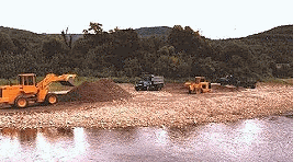
Once a widespread commercial activity in Vermont's rivers, gravel removal is now restricted to maximum annual volumes for landowner's use and for the maintenance or restoration of stream channel stability. As a commercial activity, gravel mining has proven to be extremely damaging to natural stable stream functions and has greatly increased flood and erosion damages in Vermont on stream systems that have experienced extensive mining in the past. Information on how to get assessment of potential stream sedimentation problems, approval for gravel removal projects and the effects of gravel removal on stream stability is provided in the documents below or by contacting the Rivers Program at 802-490-4741 or ANR.WSMDRivers@vermont.gov .
- VT ANR Stream Gravel Removal Policy
- Gravel Removal: Historical Perspective and Current Practices
- Impact Assessment of Instream Management Practices on Channel Morphology
River Management Training Opportunities
Rivers and Roads
A comprehensive program mandated by the Vermont Legislature and developed by Vermont ANR in cooperation with VTrans that explains the workings of rivers and how to design, construct and maintain roads and bridges to create greater river stability and more flood resilient transportation infrastructure.
View Rivers and Roads training featured on Vermont PBS's Outdoor Journal
- Rivers and Roads Training Program: General Overview
- Rivers and Roads 2012-2016 - A Report on the First Five Years
- Rivers and Roads Training Program: 6-Year Progress Report (Short Report)
Introductory Level – Tier One
Online training that provides a general awareness and understanding of river processes, aquatic habitat and how transportation infrastructure affects and is affected by river stability.
View the Roads Training Presentation(web based, with audio and video)
Download the slides from the Roads Training Presentation (2.24 MB, this PDF version of the presentation has no audio or video)
Download the slides from the Roads Training Presentation (25.77 MB, this PowerPoint version of the presentation has no audio or video)
Intermediate Level – Tier Two
Classroom and field based training that focuses on accommodating channel stability and minimizing impacts to aquatic habitat in design, construction and maintenance of transportation infrastructure.
- Tier 2 Training Schedule and Dates for 2025
- Tier Two Overview
- Field guide - single page format
- Field guide - booklet form
Advanced Level – Tier Three
Training in the use of the ANR Standard River Management Principles and Practices to select, design and oversee construction of projects involving river instability and crossing structure repair and/or replacement.