Wetland Layers
The Wetlands Program edits the Wetland Advisory Layer and the Vermont Significant Wetlands Inventory (VSWI). The VSWI displays Class I and II wetlands, which are protected by the Vermont Wetland Rules. The VSWI maps are intended to denote approximate wetland locations and boundaries. They should not be relied upon to provide precise information regarding the exact location, configuration, or size of wetlands (see Section 3.2 of the Vermont Wetland Rules). Additionally, not all wetlands are mapped, and wetlands not mapped on the VSWI may still be considered significant. Only a qualified wetland scientist may determine the absence or presence of a wetland and its boundaries.
The Wetland Advisory Layer is a supplemental wetland mapping layer. It is not a regulatory layer, but it may provide better information on the size and configuration of wetlands in the landscape. There are multiple sources for the advisory layer, but this layer is not uniform across the state due to its origins.
To learn more about the different layers used to help find wetland areas, click on the following links:
Wetland Map Edits
A complete overhaul of the VSWI is underway, and improved mapping of the entire state will be available soon. The University of Vermont Spatial Analysis Lab and Saint Mary’s University of Minnesota are mapping wetlands using aerial imagery and spot checks to refine the National Wetlands Inventory (NWI) maps. Once approved by the US Fish and Wildlife Service and Wetlands Program, this map will be screened for significant wetlands and transferred to the VSWI. A draft interactive map of the NWI is now available while we await VSWI updates.
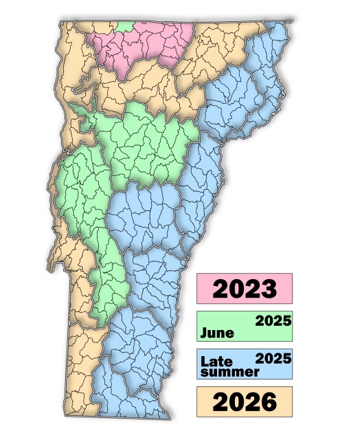
The expected dates of completion for updated VSWI (Vermont Significant Wetlands Inventory) maps.
Edits to the VSWI mapped polygons are noticed on the Environmental Notice Bulletin (ENB). Wetland additions to the VSWI are added once a wetland determination of classification is made. Wetland determinations are noticed for 14-30 days on the ENB, and final decisions are posted there as well. You may sign up for email notification of any VSWI edits or additions in your area through the ENB. Updates to the advisory layer occur quarterly on the Wetlands Inventory Map and ANR Atlas and are not noticed on the ENB.
The Secretary shall revise the VSWI maps to reflect wetland determinations issued by the Secretary pursuant to 10 V.S.A. § 914 and by the Panel pursuant to 10 V.S.A. § 915. The Secretary may also adjust the boundaries of wetlands shown on the VSWI maps to more accurately depict the location of a wetland, as determined by aerial photos, field visits, field delineations and other relevant information. Under 10 V.S.A. § 916(b), as added by Section 14 of Flood Safety Act (Act 121 of 2024), the Agency is required to complete a High Quality Wetlands Inventory, using NWI Plus mapping, for all tactical basins in the state by January 1, 2030. Wetlands identified in the NWI maps that are estimated to meet one or more categorical Class II wetlands criteria under VWR §4.6 will be proposed for addition to the VSWI.
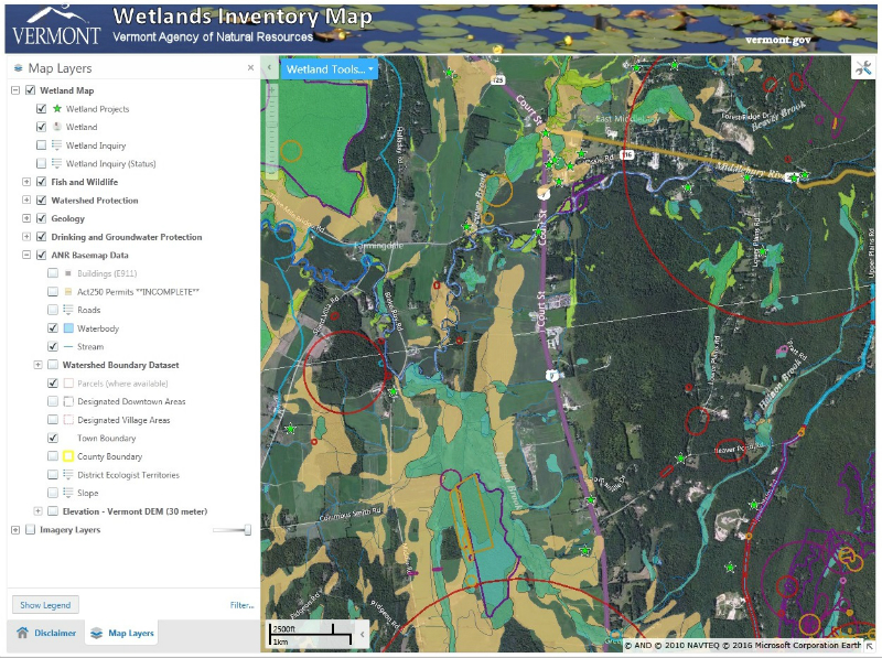
Wetlands Inventory Map
The Wetlands Inventory Map is a web-based mapping tool designed to help the public research wetland locations and features. Users may navigate to an area of interest, locate potential wetlands and other features, and create printer-friendly maps. The tool shows mapped wetland boundaries from the Vermont Significant Wetlands Inventory (VSWI), as well as wetland indicators including hydric soils, flood hazard zones, standing water, and vernal pools. Other features of special consideration when planning wetland-related projects are perennial surface waters (lakes & streams), rare, threatened and endangered (RTE) species and natural communities, impaired waters, and ground and surface water protection areas.
 Mapping of hydric (poorly drained wet) soils and aerial interpretations of wetland locations are useful tools for land use planning.
Links
- Wetland Inventory Map
- Wetlands Inventory Map Tutorial (Revised April 2022)
- How to Create a Shapefile Using the VSWI (New August 2018)
- Missisquoi Mapping Project Presentation, 2019
- Wetlands Screening Tool
- VSWI Edit Petition: Use this form to request a change in a Vermont Significant Wetlands Inventory mapped wetland.
- Wetland Polygon GDB: a blank geodatabase formatted the same as the Vermont Significant Wetlands Inventory (VSWI) for submittal of wetland determination polygons and requested map edits.
- Join VSWI Submittal Group ARCGIS Online Members can gain access to the "Wetland Submittal from Partner" layer. This layer may be used to add wetland polygons associated with applications and petitions and can be viewed by the Wetlands Program.
- Tricks & Tips, Tools & Techniques to Aerial Interpretation for Wetland Presence in Vermont
Wetland Screening Tool
This tool is recommended for realtors, potential buyers, town administrators, conservation commissions, and landowners. It is the best means of gaining a comprehensive view of potential wetlands on a property short of a site visit by a wetland professional, and understanding the layers you are looking at. The wetland screening tool was developed to help you navigate all the mapping layers which indicate a property may have wetlands on it. In addition to the Vermont Wetland Inventory Maps, the tool also screens for nearby hydric soils, wetland projects, wetland permits, wetland natural community types, and wetland advisory layers. The results for a given property are listed for you to see, with explanations of each layer and recommended next steps. You can also produce a map of the results. To get started, all you need is the 911 address or the SPAN number for an undeveloped property.