Vermont owes its beautiful mountains and lush river valleys to the underlying geology. Bedrock and glacial deposits create the landscape and influence everything on the surface - soils for farming, lakes, ponds and rivers, mountains for recreation and resources, and even the plants and animals which thrive in and on these materials. The geology of Vermont and maps which portray that geology have a multitude of uses. To see more uses of geologic maps, see Year in review, a report submitted to the Association of American State Geologists, 2016 and the DEC FY2018 Performance Report with maps summarizing a) essential geoscience for Vermont communities and b) areas of hazard mapping.
 What is a geologic map?
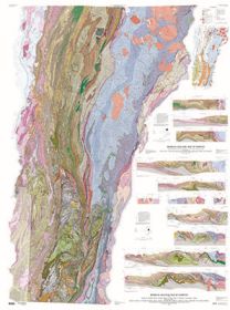
A geologic map shows the distribution of materials at or near the Earth’s surface. Rock types or unconsolidated materials are generally grouped into map units and depicted using different colors. Geologic maps show information collected manually in the field by walking Vermont’s landscape. Maps are labor intensive and are based on detailed field work in a variety of terrains. Maps are interpretive and the degree of certainty is limited by the exposures of materials. Geologists measure features where outcrop or surficial materials are exposed, then infer geologic contacts based on these measurements. A variety of lines, symbols, and text convey information in the form of a geologic map. Measurements taken at the surface are used to predict the location of geologic units and structures at depth and these predictions are shown on cross-sections. Thus, a geologic map is the major tool for communicating geologic information to other geologists and the public.
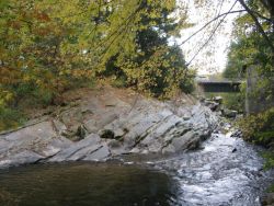
A bedrock geological map shows the type of intact, solid bedrock at or near the earth's surface. A bedrock map generally includes rock descriptions, age relationships (stratigraphic sequence), major and minor structural data, and other information. A surficial geologic map shows the type of unconsolidated materials which are beneath the top soil layers. In Vermont most of these materials were deposited during glacial ice advance and retreat or are recent stream deposits (alluvium). Some of these deposits may be important aquifers or sources of sand and gravel.
Geologic maps have been used to answer the following questions (and many more) from Vermonters:
Are there dangerous faults on my property?
What is the likely source of radioactivity in my water well? Where can I drill to avoid it?
What is the likelihood of an earthquake in my area?
What is the size and value of a sand and gravel deposit on my property?
Can you tell me about the geology of my town?
Can you explain the glacial history of the Connecticut River Valley to me?
Is there selenium in our soil? Is it a health hazard?
Do you know about the cantilever rock in Underhill? How did it happen?
Is this an impact crater? How do you know?
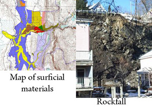
How can we mitigate the rockfall on Elm Street?
What is this rock?
Are there old volcanoes in Vermont?
What is the smell in my water? Is it dangerous? Can I fix it?
Is there oil or natural gas on my property?
What is the likelihood of failure along this stream bank?
Are there hazardous areas in Smugglers Notch? Why?
How can we mitigate the landslide area in Jeffersonville?
Is there a buried aquifer in my town?
Are there favorable areas for my water supply?
See Minnesota's report for information about using geologic maps to solve community problems.
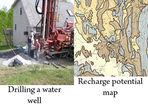
 Want to locate a public water supply or drill a private well?
Bedrock and surficial geologic maps, in conjunction with water well data, are used to understand groundwater resources and help locate and protect resources.
Rock properties, unconsolidated materials, and structures such as fractures impact how water and/or pollutants move through the subsurface.
Water well logs provide additional subsurface information.
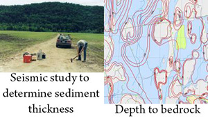
Derivative maps showing predicted depth to bedrock can be helpful when estimating drilling costs or, in conjunction with materials, when locating buried aquifers.
View groundwater maps and projects.
 Do you live in an area subject to some type of hazard or is there new building proposed for these areas?
We provide information and education about geologic hazards and measures to mitigate the risk. Maps and reports displaying the nature of physical geologic hazards such as earthquakes, landslides, and erosion are available. These maps are based on basic bedrock and surficial map information plus additional detailed analyses.
See information and projects about earthquakes, landslides and rockfalls.
 Are you concerned about contaminated water wells or drainage issues associated with farms?
Are you concerned about naturally-occurring geochemical hazards such as radioactivity and arsenic?
Geologic maps and interpretation of data are used to solve this type problem.
Links: Geology and Health
Our maps are available as digital data too. The surveyed geology, mineral resources, and topography are presented in digital format for use with other data sets, computer-aided analysis of data, or map plotting.
Links: Natural Resource Atlas on-line, VCGI, National Geologic Map Database, Our Open File publications and GIS data, Geodatabase files
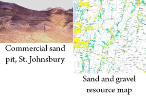 Want to build a new road or parking lot, find a source for highway or infrastructure materials, or site a project?
Surficial geologic maps show sand and gravel deposits and other unconsolidated materials.
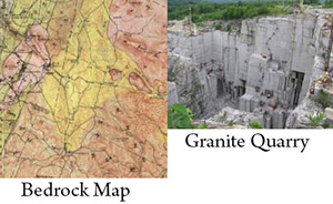 Are looking for building stone or crushed rock for a driveway or decorative purposes?
Are you looking for industrial minerals and deposits?
Occasionally, historic preservation groups seek sources for building stone to refurbish a structure.
Bedrock maps portray the different rocks types in Vermont.
The USGS mineral resources data (MRDS) shows the location of quarries for dimension stone, crushed rock, and sand and gravel.