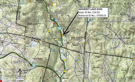
In April 2021, risk reduction measures were implemented at Amherst Lake Dam in Plymouth. A brief overview of these measures and other considerations are provided below. For more information, please refer to the 2021 Dam Safety Inspection Report and the Water Control Plan. Please contact the Dam Safety Program with questions or concerns at 802-622-4093 or Benjamin.green@vermont.gov.
- Dam History: The dam was reportedly originally constructed in 1950 by Central Vermont Public Service but was passed to private ownership circa the 1980s as it remains today.
-
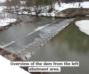
Dam Configuration: The dam is a concrete gravity dam with a principal spillway and outlet works. The dam is about 115 feet long with a structural height of 17 feet and raises the water level over the natural Amherst Lake on the order of 6 to 8 feet.
-
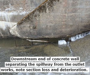
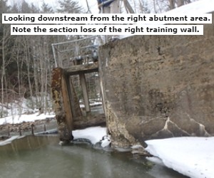
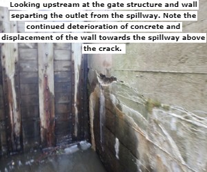
Condition: The dam has been rated in POOR condition since at least 2005 with deterioration including structural cracking and section loss of the right abutment and outlet works gate area. Following a state inspection on March 18, 2021 increased deterioration and stability concerns were noted, leading to the implementation of risk reduction measures at the dam.
-
Potential Consequences: The dam is currently classified as a SIGNIFICANT hazard potential, meaning failure or mis-operation of the dam will likely result in no probable loss of human life but can cause economic loss, environmental damage, and or disruption/impact to other concerns. Based on the current dam Emergency Action Plan (EAP), a sudden failure could result in the partial inundation of approximately 19 homes and 1 State Park located along Echo Lake, immediately downstream.
-
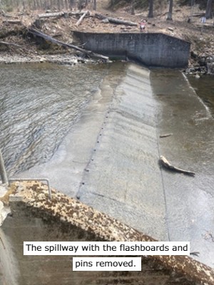
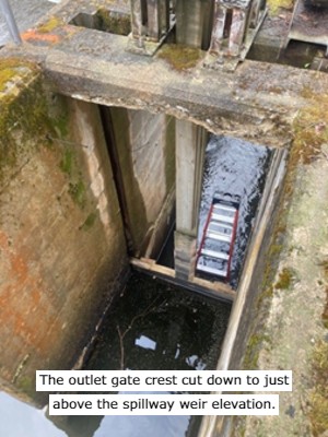
Risk Reduction Measures: The following measures will be implemented to reduce loading on the dam: remove the flashboards, the associated pins, and adjust the height of the top of the gate to maintain the lake level at the spillway crest, about 2 feet lower than recent summer lake levels. The measures will be performed to minimize impacts to natural resources including fisheries and water quality (refer to the Water Control Plan for more information).
-
Impacts to Existing Uses of Amherst Lake: It is anticipated that the lake will generally maintain its surface area and shape and most existing summertime recreational uses. However, the lower water level will cause some challenges, particularly for the launching of trailered vessels from the Fish & Wildlife boat ramp.
-
Dam Owner Responsibility: While the dam supports public uses on Amherst Lake the risk, liability, and responsibility associated with ownership of the dam falls entirely to the private owner.
-
Regulatory Jurisdiction: The dam is a non-power, non-federal dam capable of impounding more than 500,000 cubic feet of water (11.48 acre-feet) and is therefore under the full regulatory jurisdiction of the Vermont DEC Dam Safety Program and State Statute 10 V.S.A. Chapter 43: Dams.
-
Next Steps: The risk reduction measures are not considered a permanent solution. Permanent measures such as dam rehabilitation or dam removal will need to be pursued. Returning the lake elevation to recent summertime water levels will not be permitted unless the dam is rehabilitated.
-
Additional Public Outreach:
-
State officials plan to attend the Town of Plymouth Selectboard meeting on May 3rd to provide information and answer questions.
-
Refer to DEC and ANR social media sites.
-
Refer to signage posted at the dam and Fish & Wildlife boat ramp.
-
Contact the Dam Safety Program at 802-622-4093 or Benjamin.green@vermont.gov
-
Photos:
(April 2021)
(March 2021)