Radioactivity - Naturally Occuring in Rock, Soil and Water
 Radionuclides in the Champlain Valley have been documented in primary sedimentary layers, plus as secondary coatings along fractures (McKeown, 1951 and Whitten, 1988). Bedrock mapping in the Colchester quadrangle (Kim and Thompson, 2002) focused in an area where domestic wells exceeded gross alpha standards. Detailed mapping, structural analysis, and geochemistry provided broad-based understanding of the radionuclide problem and serves as a prototype for future analysis throughout the State of Vermont.
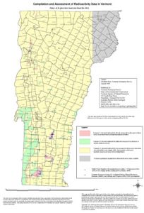
A statewide compilation of radioactivity data (including uranium and thorium) and an accompanying Radioactivity Map Fact Sheet were completed by Kim (OFR VG2002-1). The map is a compilation of areas where ground-based and airborne geophysical and geological surveys have indicated the presence of elevated naturally occurring radioactivity relative to surrounding areas. Public water supplies with gross alpha radioactivity equal to or greater than 15 picocuries/liter and uranium occurrences are also shown. Elevated radioactivity areas determined via these surveys in the Milton-Colchester (Plate 4) area coincide with many of the locations of domestic groundwater wells with elevated radioactivity.
Gross Alpha Radiation and Drinking Water (Health Dept)
Regional Compilation of Sources of Groundwater Contamination (arsenic and radionuclides), (Kim, 2014, Poster for west-central VT)