Vermont DEC and Partners are developing methods and mapping to identify high priority projects to restore and protect stream, wetland, and floodplain functions.
Vermont’s Functioning Floodplains Initiative
- Functioning Floodplains Initiative - 4/2021
- Recording of second Stakeholder meeting and presented slides – 5/2021
- FFI Partner Training video 5/2023
- Recording of first Stakeholder meeting, presented slides and request for User Stories - 8/2020
- Scope of services under contract, click here for details - 7/2020
- Functioning Floodplains Initiative User Guide (with appendices) - 10/2023
Growing public interest in improved water quality, ecological integrity, and flood resiliency is creating a need for better tools to aid the restoration and protection of rivers, wetlands, and floodplains. A Functioning Floodplains Initiative is now underway in Vermont to identify nature-based projects through scoring, tracking, and mapping of floodplain functions and quantification of their social values.
These analyses will start by mapping hydrologic disconnections (i.e., departures caused by human-related constraints). Opportunities to achieve ecosystem function will then be identified by modelling those fluvial processes that may need protection or that could be restored through re-connection projects. Benefit-cost data will be used to prioritize sets of restoration and protection projects in the stream network to support societal agreements for project implementation. Site-scale surveys and modelling are required to support project designs that maximize functional lift and minimize O&M costs. Post project monitoring is conducted and tracking programs are updated.
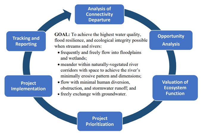
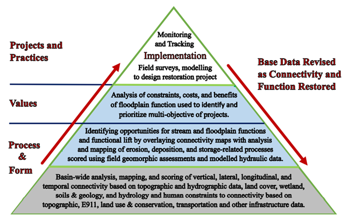
From Basin to Site Scale Assessments: Web-based mapping and tracking tools will be developed to support three tiers of data collection and analysis. Basin-wide assessments of stream and floodplain connectivity and departure will assist resource agencies and towns in regional scale planning. As details of process, function and valuation are layered on, decision-support tools will aid in the selection of optimal suites of restoration and protection projects for achieving the multiple objectives of higher water quality, flood resilience and ecological integrity. These tools will also help the practitioner focus on an increasingly smaller set of reaches and potential project sites selected for implementation where site-specific measures will be required.
Mapping and Tracking of Stream and Floodplain Function
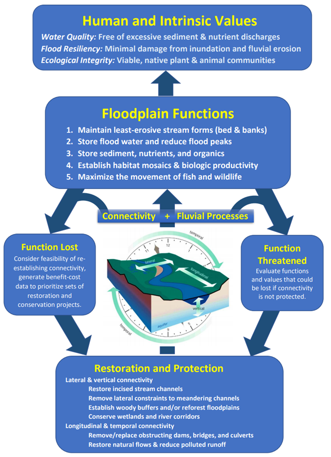
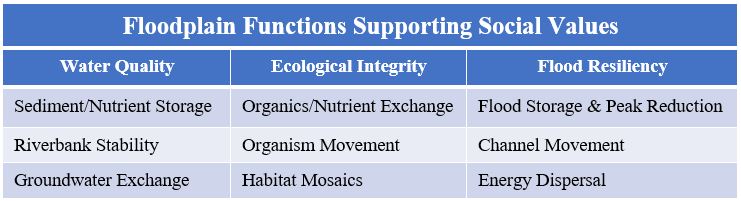
Assessing stream and floodplain functions supports the valuation of ecosystem services. Societal benefits such as safe swimming, fish and wildlife, public safety and property protection may be categorized under the general ecosystem services of water quality, ecological integrity, and flood resilience.
Floodplain function may then be evaluated, scored, and mapped based on different combinations and weighting of form and process data. The evaluation starts with connectivity departure scores, which are then weighted in varying degrees with scores reflecting the magnitude of beneficial fluvial processes that could either be protected or restored in a given reach or valley segment.
Connectivity Scoring and Mapping
A departure analysis is being completed that scores and maps the degree to which stream and floodplain connectivity have departed from that which existed in the absence of human alteration or constraints such as built infrastructure or land-use conversion:
- Natural connectivity: scores for a stream and floodplain reach were it to be a:
- stream – longitudinally connected upstream and downstream and no change from the natural flow regime, with no human in-channel or cross-floodplain obstructions, and no diversions, withdrawals, or stormwater discharges that would affect magnitude, frequency, duration, and timing of instream and floodplain flows.
- floodplain – vertically connected with its full meander corridor / floodplain and a natural-vegetated riparian buffer (i.e., no incision); no human constraints that would affect the full lateral and vertical expression of fluvial process.
- Existing connectivity: score for a stream and floodplain reach reflecting the:
- stream – degree of channel /floodplain upstream and downstream obstruction as caused by dams, impoundments, bridges and culverts; plus, a score reflecting the degree of change to the natural flow regime as caused by diversions, withdrawals, stormwater discharges.
- floodplain – remaining open meander corridor and floodplain, intact riparian buffer, and level of river corridor protection factoring the degree of existing channel incision.
Departures score for stream and floodplain connectivity are created for each geomorphically delineated stream reach, which are then added together to describe departures at the sub-watershed and basin scales.
Fluvial Process Scoring and Mapping
Stream Process (Erosion & Deposition) – describes sediment, nutrient, and debris movement within the channel and floodplain as influenced by channel flow depth, slope, and roughness factors.
River reaches that have become vertically and laterally disconnected from their floodplains are exposed to higher stream power during flooding, since flood waters are less able to spill onto the floodplain to dissipate shear stress. When stream power exceeds thresholds for transporting the available sediments, then the bed and banks of the channel may destabilize, habitats scour, and nutrient loading may increase.
Opportunities to increase stream and floodplain function, based on the feasibility of restoring and protecting connectivity, will be mapped and assessed against sediment regime classifications describing stage of channel evolution and departure from natural sediment processes. Using this method, feasible projects of different types and sizes may be identified that provide significant opportunity to achieve and maintain natural sources, transport, and storage of sediment and nutrients within the stream network.
Floodplain Process (Flow & Material Storage) – describes the frequency and duration of runoff to the channel and onto different floodplain and wetland features and the volume-duration of flow and material storage based on different floodplain and wetland characteristics.
When inundated, floodplains and riparian wetlands store floodwater, fine-sediment, and nutrients for a period of time. To begin understanding these processes, floodplains are mapped and inundation extents for various return intervals are modelled to provide insight into the volume, frequency, and duration of runoff and storage in different floodplain and wetland features.
Opportunities to increase floodplain function, based on the feasibility of restoring and protecting connectivity, will be mapped and assessed using data describing the departure of natural floodplain and wetland hydrology and hydraulics. Using this method, feasible projects of different types and sizes may be identified that would provide significant opportunities for flow and material storage.
Assessment of Stream and Floodplain Functions
Composite scoring and mapping of form and process departures will be used to evaluate the loss of function that, when viewed in the context of existing technical, social, and financial constraints, will reveal opportunities for restoration or protection projects that would maximize river and floodplain connectivity and create significant value to society.
The prioritization of restoration and protection projects to achieve one or more desired value will be based on the opportunity scores for the functions known to support different values, i.e., where can we achieve the greatest multi-functional lift that will have a significant positive and cost-effective impact on water quality, ecological integrity and/or flood resilience?
Assessing Societal Values and Project Priorities
Streams, floodplains and riparian wetlands may be targeted as priorities for protection and restoration depending on the magnitude, network location, cost effectiveness, and combination of functions that are either present or may be feasibly restored. An analysis of data within the stream-floodplain network may be used to identify the suite of projects and practices (i.e., such as those listed below) necessary to achieve meaningful results from project implementation.
Valuation of projects to protect and restore streams, wetlands and floodplains will be assessed for relevant aspects of water quality, ecological integrity and flood resilience. Analyses may include the benefit-cost comparisons of different practices for implementation, O&M, equivalent unit costs, and savings. Such data, and the translation of form and process data into functions and values, will be very useful in communicating the need and gaining support for natural stream and floodplain protection and restoration to landowners, the community, and state and federal funding programs.
Floodplain Connectivity (vertical and lateral) achieved through projects and interventions, such as:
- berm and levee removal or modification;
- floodplain cuts and benching;
- buyouts and removal of structures from the river corridor and floodplain;
- wood and rock additions to increase roughness and bed elevations;
- riparian and floodplain reforestation;
- wetland restoration;
- river management, i.e., limiting channelization practices unrelated to public safety; and
- land protections, e.g., easements, land purchase, and municipal / state land use regulation.
Stream Connectivity (longitudinal and temporal) – achieved through projects and interventions, such as:
- stream crossings replacement with geomorphically and AOP-compatible structures;
- derelict dam removal (including other structures that impound flows);
- natural flow regime restoration at water diversions and withdrawal structures;
- ditch system removal/retrofit to minimize erosion;
- gully stabilization; and
- stormwater treatments to protect downstream channels.
Contributors to the Vermont Functioning Floodplain Initiative (01/27/2020)
The assessment, mapping, valuation, and tracking of alluvial streams and floodplains in the Lake Champlain basin to achieve the goals of the Functioning Floodplain Initiative (FFI) will involve collaboration among individuals working on relevant aspects of this overall effort. The Vermont Team consists of engineers, geomorphologists, hydrologists, ecologists, and geospatial scientists at state and federal agencies; local and national NGOs; researchers at the University of Vermont (UVM) who are studying various aspects of floodplains, river corridors, and wetlands; and consulting practitioners who regularly assess floodplain and river corridor condition, implement reconnection projects, and engage the public to identify and prioritize reconnection projects.
Vermont Agency of Natural Resources
Vermont Agency of Transportation
U.S. Environmental Protection Agency, Region 1
U.S. Fish and Wildlife Service, Partners for Fish and Wildlife
The Nature Conservancy, Vermont Chapter
Milone & MacBroom, Inc.
Fitzgerald Environmental Associates
South Mountain Research and Consulting
Fluvial Matters, LLC
Stone Environmental, Inc.
University of Vermont
Gund Institute for Environment
Lake Champlain Basin Program
Lake Champlain Sea Grant Program
Vermont Water Resources and Lake Studies Center
Vermont EPSCoR Program