Recreational Use
Click here to view the fullscreen dashboard (opens new window): https://www.arcgis.com/apps/dashboards/b1ecde5ef6974fb6a440b47deb4e5e7d
Click here to view the fullscreen dashboard (opens new window): https://www.arcgis.com/apps/dashboards/b1ecde5ef6974fb6a440b47deb4e5e7d
Click here to view the fullscreen dashboard (opens new window): https://www.arcgis.com/apps/dashboards/ef256254e36640dcae3c3d2fcde65a42
Click here to view the fullscreen dashboard (opens new window): https://www.arcgis.com/apps/dashboards/28e0b1c111b4420d94eefb78da037d53
Click here to view the fullscreen dashboard (opens new window): https://www.arcgis.com/apps/dashboards/c3c9d7ee15c644a3ba7850da2da7d247
From 2016-2023, the Vermont Geological Survey participated in the Water Use and Data Research (WUDR) Program, funded by the United States Geological Survey. A major goal of the WUDR program is to improve the availability, quality, compatibility, and delivery of water-use data collected or estimated by states to support National water-use assessments.
The maps are a summary of data by county of existing bedrock well information as shown on the statewide maps. Maps based on surficial information are in progress. Detailed groundwater resource projects at a scale of 1:24,000 are listed under the Town/Quadrangle projects and Open-File reports.
What is drought? A period of unusually dry weather that persists long enough to cause problems such as crop damages or water shortages. There is meteorological, agricultural and hydrologic drought. Impacts of drought on groundwater may lag behind the decrease in precipitation and agricultural drought. For tips on what to do during drought, ready.gov has information about all hazards.
Links to drought information:
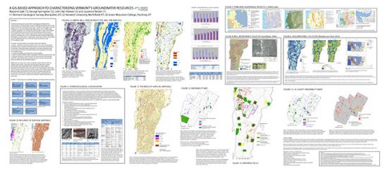 In 2008, the Geological Survey was asked to compile and assess existing datasets related to groundwater in Vermont.
PLAN - MAP - TEST - PROTECT