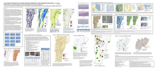
groundwater

Environmental Geology Reports, 1971-1975

The Environmental GeologyReport series are simplified versions of maps of bedrock and surficial materials, construction conditions, groundwater potential, solid waste disposal, sand and gravel reserves, and septic conditions. The series, developed for planning purposes, includes text and regional information.

Env Geology No 1: Geology for Environmental Planning in the Barre-Montpelier Region, Vermont, DP Stewart, 1971, 5 plates plus text 

Well Driller Reporting

Well drillers must submit well reports to the state within 90 days of completing, deepening, hydrofracturing, or abandoning a well. The Drinking Water and Groundwater Protection Division (DWGPD) maintains a database of wells drilled in Vermont, including information on location, construction, and well logs. Members of the public can access the Well Completion Reports Searchable Database to find more information about a well.

Rules

Petroleum Clean-Up Fund

Established under the authority of 10 V.S.A Chapter 59 Section 1941, the Petroleum Cleanup Fund (PCF) was created to pay, subject to available funding, for certain uninsured costs for the cleanup and restoration of contaminated soil and groundwater caused by the releases of petroleum from aboveground storage tanks (ASTs) and underground storage tanks (USTs), and for the compensation of third party claims for injury and damage caused by such a release.

Wastewater and Water Supply System Installers

The Wastewater System and Potable Water Supply (WW) Program has worked with Vermont State University to develop a voluntary WW Installer Certification Program for contractors who install onsite wastewater treatment (septic) systems and potable water supply connections.  The Program provides WW Installers with the information and training associated with the proper siting, design, and construction of wastewater systems and potable water supplies that are regulated by the Wastewater System and Potable Water Supply Rules. 

Geothermal Energy

Geothermal log graph

The Geological Survey focused on collecting water well temperature data as an indicator of temperature gradients, radionuclide chemistry as a potential natural augmentation to heat production, thermal conductivity measurements which impact heat flow, and structural data particularly rock anisotropy and fracture data. Thermal conductivity and geochemical data for 40 rock samples plus 17 water well temperature records were uploaded to the National Geothermal Data System for easy access.

Subscribe to groundwater