Air Quality and Climate Division Contact Information
Air Quality and Climate Division
Davis Building - 4th Floor
One National Life Drive
Montpelier, VT 05620-3802
Main Telephone: 802-828-1288
The Air Monitoring Section maintains an air-quality monitoring program to measure ozone, nitrogen oxides, carbon monoxide, particulate matter, sulfur dioxide, volatile organic compounds, carbonyls and sulfate. There are monitoring stations in Underhill, Burlington (2/2024 temporary suspended), Rutland, and Bennington. Below is the configuration of Vermont's ambient air monitoring network for 2023.
Click on Site location to view full Site Information. (Mt. Snow & Bennington Old Reservoir unavailable)
The Air Monitoring Section operates the division’s statewide ambient air monitoring network for the measurement of EPA criteria pollutants- ozone, particulate matter, nitrogen oxides, carbon monoxide and sulfur dioxide, as well as meteorological parameters such as wind speed and direction, temperature, barometric pressure, precipitation and solar radiation.
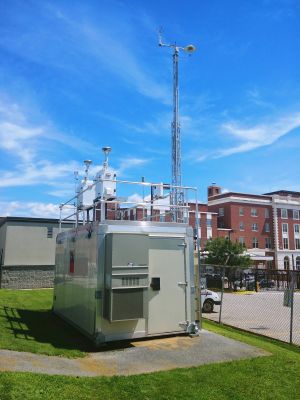
EPA site number: 50-021-0002
Address: Parking lot adjacent to 9 Merchant's Row
County: Rutland
Date site established: 1/1/71
Current status: Active
Site coordinates:
Latitude: 43° 36' 29" (43.608056°)
Longitude: -72° 58' 58" (-72.982778°)
Elevation: 179 m (589 ft)
The Air Quality & Climate Division (AQCD) requires that emissions from most regulated air pollution sources exhaust through an unobstructed, vertical stack of sufficient height to ensure appropriate upward dispersion of the exhaust, thus minimizing the ground level concentration of air pollutants where individuals may be exposed.
When a Facility submits certain information to the Air Quality & Climate Division, a responsible official of the Facility (see definition below) must attest to its accuracy. This form is required for Permit Applications, Requests for Transfer of Ownership of a Permitted Facility, Annual Registration Submittals and Annual/Semi-Annual Compliance Reports.
An Air Quality Impact Evaluation (AQIE) is an evaluation, using approved computer models, of the ambient air quality impacts that the public may be expected to be exposed to due to air pollution emissions from one or more facilities. The pollutants emitted by the facility, the emission rates, stack parameters (e.g. heights, flow rates, temperature), building parameters, terrain, and meteorology are all taken into account to predict potential ambient impacts caused by the facility. An AQIE may be conducted for criteria pollutants (e.g. CO, NOx, PM, SO2) or hazardous air contaminants (e.g.
The federal Clean Air Act requires states to submit plans to ensure the attainment and maintenance of national ambient air quality standards (NAAQS). The common term used to refer to these federally enforceable plans is "State Implementation Plans" or SIPs. The six criteria pollutants as defined by the U.S. Environmental Protection Agency (EPA) are carbon monoxide, lead, nitrogen dioxide, ozone, particulate matter, and sulfur dioxide. SIPs are also prepared to protect visibility at federal Class I areas consisting of national parks and wilderness areas.