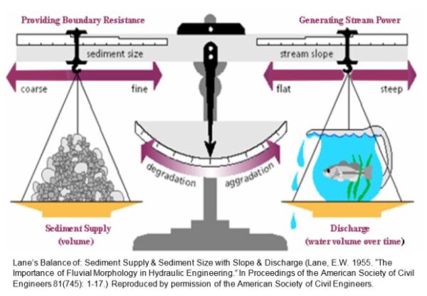
Rivers are in a constant balancing act between the energy they produce and the work that must be done to carry the water, sediment and debris produced in their watersheds. A change in any one of these factors will cause adjustments of the other variables until the river system comes back into equilibrium (balance). These changes can be caused by natural events and by human activity. The impact of which may be seen immediately or for decades after the activity occurred.
The goal of managing toward, protecting, and restoring the equilibrium condition of Vermont rivers is to resolve or avoid conflicts between human investments and river dynamics in a manner that is technically sound, and both economically and ecologically sustainable.
The Vermont Stream Geomorphic Assessment Handbooks have been developed as tools to use in assessing, understanding, and evaluating the condition of the river system. The information gathered can be used for basin planning; river and riparian corridor protection, management, and restoration projects; aquatic and riparian habitat assessment; and hazard assessments to reduce property loss and damage from riverine erosion during floods.
The Rivers Program provides the technical assistance to conduct geomorphic assessments of streams and their watersheds. Contact your regional ANR River Scientist for data forms, assessment protocols, and geomorphic reference tools used by the State to assess stream condition and responses.
Resources
Why do Geomorphic Assessments?
- Fluvial Geomorphology: A Foundation for Watershed Protection, Management and Restoration
- Vermont River Corridor Management Program Definition and Application of Fluvial Geomorphology
Vermont Geomorphic and Habitat Assessment Protocols
- Vermont Agency of Natural Resources Stream Geomorphic Assessment; Program Introduction
- Reach Habitat Assessment Protocol Report
-
Vermont Stream Geomorphic Assessment Protocols
- Phase 1 – Watershed Assessment
- Phase 2 – Rapid Field Stream Assessment
- Phase 3 - Survey Assessment
-
Assessment Handbook Appendices
- A1 - Phase 1 forms
- A2 - Phase 2 field forms
- A3 - Phase 2 RHA forms
- A3 - RHA tally forms
- A4 - Phase 2 RGA forms
- A5 - Phase 3 field forms
- B1 - Phase 1-2 DMS instructions
- B2 - Spreadsheet Instruction
- C - Channel Evolution Models
- D - Topos & Aerials
- E - Corridor Definition
- F - Geologic Info
- G - Bridge and Culvert Protocols
- H - Meander Geometry
- I - Classification Systems
- J - Hydraulic Geometry Curves
- K - Identification of Bankfull Stage
- L - Flood History
- M - Delineation of Bad Features
- Memo - SGA Revised Field Form RGA
- N - Soil Stratigraphic & BEHI
- O - Shear Stress
- P - Feature Indexing Tool Manual
- Q - Glossary
- Phase 2 Assessment Workbook
- Phase 3 Spreadsheet
Vermont Bridge and Culvert Assessment Protocols
- 2009 Bridge and Culvert Assessment Protocol
- The Vermont Geomorphic Compatibility Screening Tool Report
- The Vermont Aquatic Organism Passage Screening Tool Report
- Vermont Regional Hydraulic Geometry Curves; 2006
Where to Access and View Data
- Stream Geomorphic Assessment and Bridge & Culvert Data Management System (SGA DMS)
- Bridge and Culvert Data Management Manual
- Geomorphic Assessment Viewer (MapServe - ANR Natural Resources Atlas)
Assessment Results
Sample Reports
- Leach Stream Phase 1 Geomorphic Assessment
- Lower Passumpsic River Tributaries River Corridor Plan
- Data shows floodplains are key to stream stability and Lake Champlain
Model RFPs
Educational Materials and Links
- ANR Riparian Buffer Guidance
- Defining River Corridors Fact Sheet
- River Corridor Protection and Management Fact Sheet
- The Streamside Sentinel
- Values of Riparian Buffers