Including: Salmon, Canoe, Sacketts, East Putney, Chase, Fullam, Mill, And Morse Brooks and portions of the Connecticut River
 What's New
Implementation of the 2021 West, Williams, Saxtons Tactical Basin Plan is underway.
The PLAN and StoryMap provide:
- an overview of the basin
- current water quality conditions
- priority areas for implementation and
- strategies and actions to improve both water quality and aquatic habitat conditions
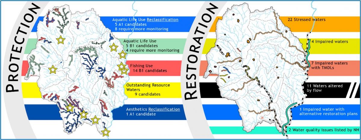
Targeting restoration and protection strategies to the land use sectors of agriculture, developed lands, wastewater and natural resources provides a framework for basin plan implementation focused on the sources of pollutants. Projects prioritized for implementation over the upcoming five years range from land protection through river corridor easements and acquisition, to stormwater and river corridor planning, to floodplain restoration and dam removals. Almost 100 strategies are put forth in this plan while over 250 potential projects are listed in the Watershed Project Database at the time of this plan’s development.
Public participation is essential to implementing the actions laid out in this plan as many of the focus areas are on privately held riverbanks and lakeshores. Voluntary involvement makes these projects possible. If you are interested in working on improvement projects on your land, please contact:
Marie Levesque Caduto, Watershed Coordinator
Vermont ANR / Department of Environmental Conservation
100 Mineral Street, Suite 303
Springfield, VT 05156-3168
Phone: 802-490-6142
Email: Marie.Caduto@vermont.gov
Two public meetings were held in August of 2021 to gather feedback on the plan. Both meetings were recorded and can be viewed at the links below. Meeting Notes are also available.
- August 11 – Public Meeting Recording
- August 17 – Public Meeting Recording
All public comments were addressed in the Responsiveness Summary which is included in the Plan as Appendix H.
Additional documents requests from public meetings:
- USACE Ball Mountain Sedimentation Study-Draft Report May 1996
- USACE Ball Mountain Sedimentation Study-Draft Report May 1996 - Plate 3
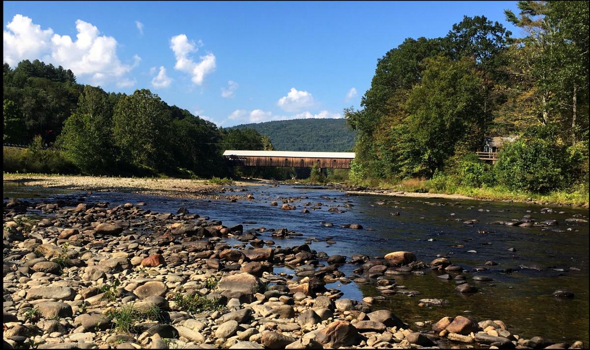
The Basin
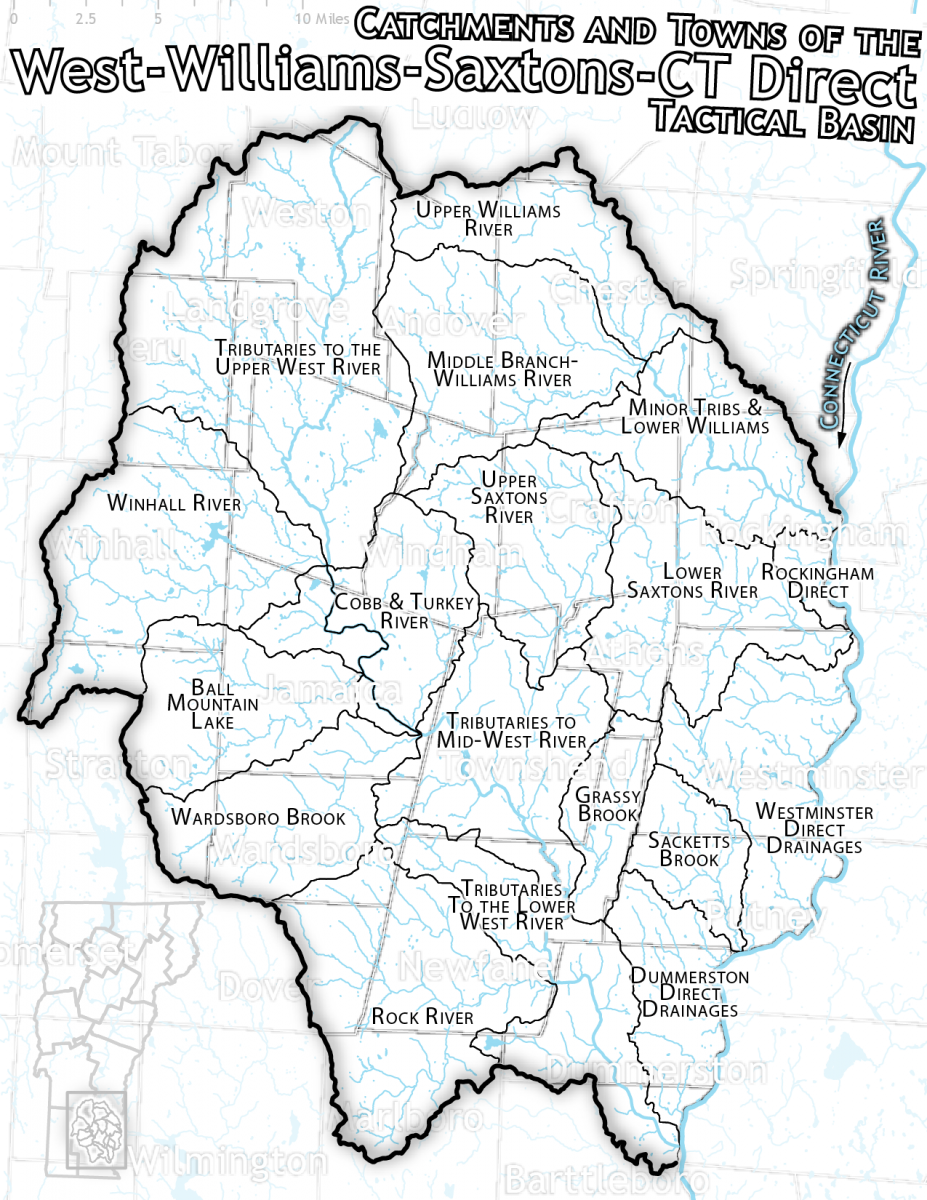
From the headwaters off of South Mountain in Mount Holly, and framed by Bromley, Stratton, and Hogback Mountains on the west and the Connecticut River on the east, Basin 11 runs from the crest of the southern Green Mountains almost to the Massachusetts line, dropping over 3700’ in elevation from the highest point in Stratton to its outlet in Brattleboro. Twenty-nine towns in full or in part, make up the Basin.
The largest of the major watersheds in the Basin is the West River draining 423 square miles flowing from Weston to Brattleboro. Its tributaries include the Rock and Winhall Rivers and Wardsboro and Ball Mountain Brooks. The Williams River running from the hills of Andover down to Herrick’s Cover in Rockingham drains 117 square miles and the Saxtons River streams 78 squares miles from Windham to Westminster.
The 26 miles of the Connecticut River mainstem covered in this basin reach from Bellows Falls to Brattleboro. The largest brooks feeding directly into the Connecticut River are East Putney and Sacketts Brooks which flow through Westminster and Putney.
The Vermont Department of Environmental Conservation’s (VDEC) tactical planning process is designed to identify and prioritize state and local water quality issues and implement on-the-ground watershed protection and restoration projects. Plans are developed in collaboration with state, federal and municipal organizations, local conservation groups, interested stakeholders, and a variety of landowners and concerned citizens to guide management of the waters in the Basins.
Find Projects in the Basin in the Clean Water Project Explorer.
2016 Basin 11-13 Tactical Basin Plan for the West, Williams, Saxtons River and lower Connecticut River & tributaries
2016 Appendices for the Plan
2008 West, Williams, Saxtons Basin Plan
2008 Appendices
Additional Resources
Water Quality Assessments:
- Watershed Assessment Reports
- Ball Mountain Brook Corridor Plan
- Rock River Watershed Phase 2 SGA
- Saxtons River Corridor Plan
- Wardsboro River Corridor Plan
- Winhall River Corridor Plan
- Williams River Corridor Plan
- Municipal Stormwater Infrastructure Maps, Stormwater Master Plans, and Illicit Discharge Detection and Elimination (IDDE) Reports
Other Supporting Documents:
- Map of Vermont's 15 Major Drainage Basins
- West River release macroinvertebrate assessment, 2004 – macroinvertebrate study before and after fall release
- Fish survey 2014 – documented fish stranding on the West River at end of release
- Brook Floater (Alasmidonta varicosa) in the West River in Vermont, 2014- fresh water mussel survey
Monitoring Data:
Assessments:
General Links:
- Planning Public Notices
- Vermont Clean Water Act 64 summary and full bill (2015)
- Priority listing of Vermont waters
- TMDLs
- Statewide Surface Water Management Strategy
- Watershed Projects Database
- Natural Resources Atlas
Major Partners:
- Bennington County Conservation District
- Bennington County Regional Commission
- Connecticut River Joint Commissions
- Connecticut River Watershed Council
- Mount Ascutney Regional Commission
- Ottauquechee Natural Resources Conservation District
- Windham County Natural Resources Conservation District
- Windham Regional Commission