River Corridor Maps
Flood Insurance Rate Maps
Maps and GIS Data
Links
Maps of River Corridors and Flood Hazard Areas are important for flood hazard area regulations, to help understand flooding hazards, for community planning to direct future growth to safer locations, and to avoid loss of floodplain functions. The maps are used in State and municipal regulations. Flood Insurance Rate Maps are additionally used by mortgage lenders and to determine flood insurance rates.
Currently FEMA is updating Flood Insurance Rate Maps across Vermont.
For more information including approximate dates please visit: bit.ly/fema-map-update
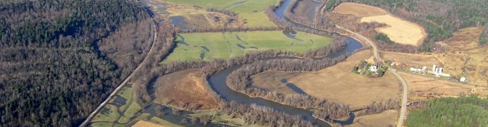
River Corridor Maps
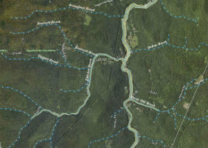
River Corridor Maps can be viewed on the Vermont Natural Resources Atlas. or on the Flood Ready Atlas. The River Corridor data are labeled by date and will be periodically updated to incorporate available stream geomorphic data.
River Corridor maps, together with the best available field data, are used by the State of Vermont for project review under Section 248 & Act 250, and the Flood Hazard Area and River Corridor Rule. Municipalities are encouraged but not required to protect River Corridors. Municipalities that protect River Corridors are eligible for incentives including the highest rate available through the Emergency Relief and Assistance Fund.
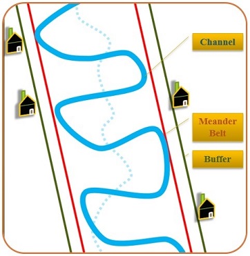
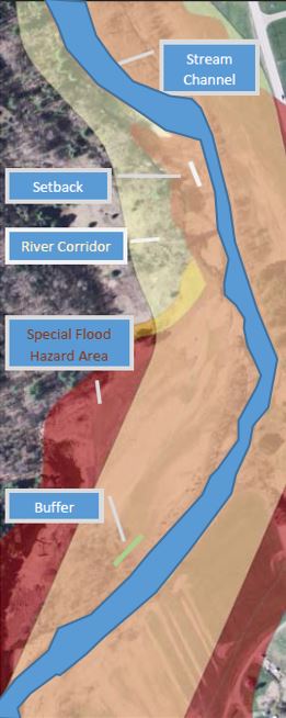
River Corridors are delineated by the Department of Environmental Conservation as described in the Flood Hazard Area & River Corridor Protection Procedure. River Corridors include the width of the meander belt of a river and an additional 50’ buffer to allow for a stable wooded bank when the river is at its equilibrium / least erosive slope. River Corridors are not mapped for small streams but do include, by definition, the area within 50 feet of the top of bank of streams with a watershed less than 2 square miles.
To view the ANR River Corridor maps:
VT ANR Natural Resources Atlas
Flood Ready Atlas: Use Flood Ready Tools to Zoom to Address and "Toggle River Corridors on"
To learn more about River Corridors, please see links below:
- River Corridors – FAQ on Flood Ready Vermont
- River Corridors on Flood Ready Vermont
- VT DEC/River Corridors
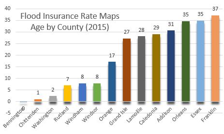
Flood Insurance Rate Maps
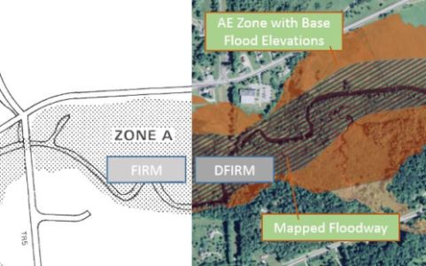
Flood Insurance Rate Maps (FIRMs) are produced by FEMA for use by communities as part of the National Flood Insurance Program. All of Vermont’s maps and studies produced by FEMA include FIRMs, Flood Boundary & Floodway Maps, Flood Insurance Studies (FIS), and Flood Hazard Boundary Maps. These maps and studies can be found at the FEMA Map Service Center.
Some counties in Vermont have Digital Flood Insurance Rate Maps (DFIRMs). While this data is available at the FEMA Map Service Center, you can also view this data on the ANR Natural Resources Atlas and on the Flood Ready Atlas. DFIRM data is available for six counties (Bennington, Chittenden, Rutland, Washington, Windham and Windsor County) and seven communities (Bradford Village, Hardwick, Jay, Montgomery, Newbury, Stowe, and Wolcott.).
What if my house is actually quite high and safe from floodwater?
Sometimes the mapped Special Flood Hazard Areas add or miss areas by mistake. If your building at the edge of a mapped flood zone, particularly where identified as a Zone “A” – it could be that the base flood will not touch your building. You may be able to document this situation with a surveyor or engineer and apply for a Letter of Map Amendment (LOMA). Contact a FEMA Map Specialist at F-MIX for more information.
For LOMA applications in a Zone A situation without official base flood elevations, please see this guidance.
To learn more about FEMA Flood Hazard Maps, please see links below:
• Flood Hazard Areas on Flood Ready Vermont
• FEMA Map Service Center – with Flood Insurance Studies and Flood Insurance Rate Maps for every community in Vermont
• FloodSmart.gov – Defining Flood Risks
Maps and GIS Data
Official GIS and other flood hazard map data may be available from a variety of sources. Not all FEMA FIRMs may be available as GIS data.
River Corridor data:
These maps are created by the VTANR and the data are available to the public by download from the VT ANR Natural Resource Atlas, or from the Vermont Center for Geographic Information (VCGI). With River Corridor data, please note the date of release, which will be noted in the name. The map available on the VT ANR Natural Resource Atlas is the most current official release.
Flood Insurance Rate Map (FIRM) data:
GIS data is only available for communities or counties that have Digital Flood Insurance Rate Map (DFIRM) data (see list above). The digital GIS data is available through FEMA’s Map Service Center (to view or for download), on the VT ANR Natural Resource Atlas (to view or for download), and the Vermont Center for Geographic Information (VCGI) (for download).
For areas outside of the communities or counties covered by the Digital Flood Insurance Rate Maps, the official data is only available on paper or in .pdf format. The pdf versions can be viewed or downloaded from FEMA’s Map Service Center. If your community participates in the National Flood Insurance Program, then the paper panels of the FIRMs should be available to view the municipal offices.
Flood Hazard Data from Federal Sources
Other flood hazard data may be available from sources including the United States Geological Survey (USGS), the Natural Resources Conservation Service (NRCS), and the United States Army Corps of Engineers (USACOE).
Some of this data is linked from Other Map Resources on Flood Ready Vermont.
Contact your ANR Floodplain Manager to inquire about other data.
Links
- VT ANR Natural Resource Atlas
- FEMA Map Service Center
- Vermont Flood Ready Atlas
- Other Map Resources on Flood Ready Vermont