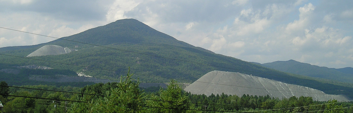
 To the left is a view to the southeast from the summit (3360') of Belvidere Mountain in Lowell, Vermont. The view from above the asbestos quarry is towards Hadley Mountain, Mt. Norris and the Worcester Range. The area is characterized by a series of northeast trending ridges and valleys. Belvidere Mountain and Hadley Mountain are separated by the Burgess Branch of the Missisquoi River. Topographic relief is 823 meters. The area is also a drainage divide with the northern slopes of Belvidere Mountain draining north to the Missisquoi River and the southern slopes draining south to the Lamoille River.
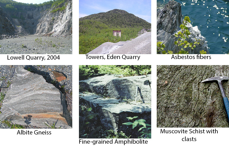
Judge M.E. Tucker found asbestos in the area in 1899 (Marsters, 1905). In the 1960's, an average of 3500 tons of ore were mined daily (Hadden, 1996) with chrysotile asbestos used in brake linings, roofing, shingles and pipe lining. Asbestos related health issues and stringent environmental laws depressed the asbestos market and the mine closed in 1993. The mountain continues to capture the interest of mineral collectors, hikers on the Long Trail, ecologists studying plant communities related to the high magnesium, iron and calcium-rich rocks, scientists investigating ways to store or "dispose" of excess carbon dioxide (CO2 sequestration), and others interested in the magnesium rich rocks. For regional geologists, the area is interesting due to the occurrence of the ultramafic rock within the ophiolite belt of the northern Appalachians, its association with a variety of metamorphosed mafic rocks, and the structural and metamorphic history. Grossular, the Vermont State Gem, is found at Belvidere Mountain along with 40 or more other rock-forming minerals. For a complete list of minerals (plus photographs) , history of the quarries, and health-related issues the reader is referred to Hadden (1996), Van Baalen and others (1999) and Carlsen and others (2015).
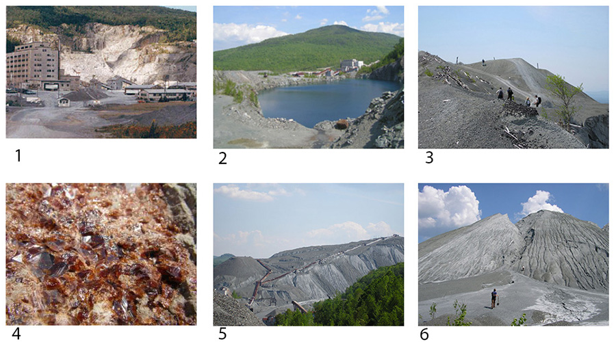
(1) Active asbestos quarry in 1985. Photo is from VGS archives. (2) Quarry pond and buildings, 2004 ( S. Krevor) (3) Scientists sampling waste piles, 2004 (S. Krevor) (4) Grossular garnet (Krevor) (5) Waste pile and gullies, 2004 (S. Krevor) (6) Erosion of waste piles, 2004 (S. Krevor)
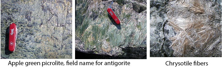
Chidester, Albee and Cady (1978) mapped the geology of the ultramafic rocks and the quarries. They mapped dunite, peridotite, and massive serpentinite surrounded by schistose serpentinite in the quarry. Asbestos * is present as slip fiber and cross fiber. Layering is prevalent in the massive rock. Talc-carbonate and quartz-carbonate rock were also mapped. Serpentinite and serpentinized ultramafic rock refer to the rock - serpentinized dunite, harzburgite and/or peridotitite. There are also Serpentine Group minerals and these include antigorite, lizardite and chrysotile. Some of these serpentine group minerals have a fibrous or asbestosform habit. The most common serpentine group mineral making up the serpentinized ultramafic rock in the quarry is antigorite. Chrysotile (the mined asbestos mineral at Belvidere Mtn.) is less common in the groundmass and tends to occur along fractures and slip planes. Actual minerals within each rock are difficult to identify without looking at a thin section or having an x-ray pattern. Chidester et al reported modal analyses of 23 samples of dunite, serpentinite and schistose serpentinite. 5 samples reported chrysotile with modes ranging from <1 to 13.2. The large waste piles at Belvidere Mountain are the result of the low modal values of ore in the host rock.
*(Asbestos is the name given to a number of naturally occurring, fibrous silicate minerals mined for their useful properties such as thermal insulation, chemical and thermal stability, and high tensile strength. Asbestos is commonly used as an acoustic insulator, and in thermal insulation, fire proofing and other building materials. Many products in use today contain asbestos. From: US EPA web site)
 Doolan and others (1982) and Stanley and others (1984) considered the ultramafic rocks to be ophiolite fragments or fault slivers. Gale (1980, 1986) mapped the area south of the summit, focusing on the metamorphosed mafic rocks and defined several fault surfaces. She mapped the Belvidere Mountain Complex which includes, from top to base, serpentinized ultramafic, coarse-grained amphibolite and garnet amphibolite, fine- grained amphibolite, greenstone, and muscovite schist (muscovite schist with small to large rounded blocks of amphibolites and greenstones). The mafic rocks define a tectonic stratigraphy underplated at the base of the serpentinite and emplaced onto the albite gneiss of the Hazens Notch Formation.
 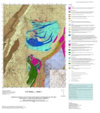 See the Bedrock Map of Belvidere Mtn and Tillotson Peak (3.0 mb pdf, Compilation 2007) . Also see, Gale, MH, 1986, Geologic Map of the Belvidere Mountain Area, Eden and Lowell, Vermont: USGS MIS map I-1560.
The Belvidere Mountain Amphibolite was originally named by Keith and Bain (1932) for the amphibolite on Belvidere Mountain. Albee (1957) mapped the greenstone south of the mountain as part of the Belvidere Mountain Amphibolite at the top of the Camels Hump Group, below and west of the Ottauquechee Formation. The coarse grained amphibolite, exposed at the summit and above the silos on the east flank of the mountain, is a dark gray, banded massive rock composed of amphibole (barroisite cores, barroisite rims, (Laird, 1977) ), epidote and garnet with lesser amounts of albite, chlorite, sphene, sericite, biotite and calcite. Calcite is present as aggregates giving some outcrops a speckled appearance. Garnet occurs as pale red or green porphyroblasts, depending on the amount of alteration to chlorite. The parallelism of amphibole laths defines the dominant lineation. The maximum thickness of the amphibolite, assuming 100% repetition by folding, is 60 meters.
 The greenstone is a fine-grained, blue-green metamorphic rock with albite porphyroblasts in relief on the weathered surface. The rock is composed of amphibole, epidote, quartz, chlorite, albite, biotite, sphene and opagues including pyrite and magnetite. Some chlorite occurs as a pseudomorph of garnet. The unit includes albitic greenstone, a schistose greenstone and a light and dark green banded greenstone (exposed on Route 118). The textural variations in the rock do not define separable map units and occur together within single outcrops.
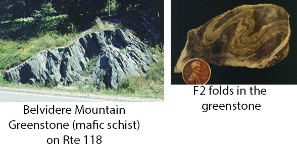 The contact of the greenstone with the coarse grained and fine grained amphibolites, the serpentinite, and the pelitic schist/muscovite schist are fault contacts marked by fault slivers and thin talc zones. The foliation in the greenstone becomes more prevalent, pervasive and closely spaced at the contacts with the serpentinite. The contact of the greenstone with the albite gneiss and with schists of the Hazens Notch Formation is interpreted as a fault contact.
Some suggested references for the geology of Belvidere Mountain:
Albee, A.L., 1957, Bedrock geology of the Hyde Park quadrangle, Vermont: U.S. Geological Survey Quadrangle Map GQ-102, scale 1:62,500.
Cady, W.M., Albee, A.L., and Chidester, A.H., 1963, Bedrock geology and asbestos deposits of the upper Missisquoi Valley and Vicinity, Vermont: U. S. Geological Survey Bulletin 1122-B, Contributions to Economic Geology, 78 p.
Carlsen, KS, Gale, MH, Thompson, WB, and Kierstead, M, 2015, Belvidere Mountain asbestos quarries Lowell/Eden, Vermont: Rocks and Minerals, vol 90, no. 6, p. 510-546.
Chidester, A.H., Albee, A.L., and Cady, W.M., 1978, Petrology, structure and genesis of the asbestos-bearing ultramafic rocks of the Belvidere Mountain area in Vermont: U.S. Geologic Survey Professional Paper 1016, 95 p.
Doll, C.G., Cady, W.M., Thompson, J.B., Jr., and Billings, M.P., 1961, Centennial geologic map of Vermont: Vermont Geological Survey, scale 1:250,000.
Doolan, B.L., Gale, M.H., Gale, P.N., and Hoar, R.S., 1982, Geology of the Quebec re-entrant: Possible constraints from early rifts and the Vermont-Quebec serpentine belt: in St. Julien, P. and Beland, J., eds., Major structural zones and faults of the northern Appalachians: Geol. Assoc. of Canada Spec. Paper 34, p. 87-115.
Gale, M.H., 1980, Geology of the Belvidere Mountain Complex, Eden and Lowell, Vermont: Master of Science thesis, University of Vermont, Burlington, Vermont, 169 p.
Gale, M.H., 1986, Geologic Map of the Belvidere Mountain Area, Eden and Lowell, Vermont: U.S. Geological Survey Misc. Investigations Series map I-1560.
Goff, F. and Lackner, K.S., 1998, Carbon dioxide sequestering using ultramafic rocks: Environmental Sciences, vol. 5, no. 3, p. 89-100.
Keith, S.B. and Bain, G.W., 1932, Chrysotile asbestos: I, chrysotile veins: Economic Geology, vol. 27, p. 169-188.
Kim, J., Gale, M., Laird, J. and Stanley, R., 1999, Lamoille River Valley bedrock transect #2: in Guidebook to Field Trips in Vermont and Adjacent Regions of New Hampshire and New York: 91st Annual New England Intercollegiate Geological Conference Meeting, Burlington, Vermont.
Hadden, S.H., 1996, Minerals of the quarries of Lowell-Eden, Vermont: Rocks and Minerals Magazine, vol. 71, no. 4, p. 236-246.
Laird, J., 1977, Phase equilibria in mafic schist and polymetamorphic history of Vermont: Ph.D. thesis, California Inst. Tech., Pasedena, California.
Laird, J. and Albee, A.L., 1981, Pressure, temperature, and time indicators in mafic schist: their application to reconstructing the polymetamorphic history of Vermont: American Journal of Science, v. 281, p. 127-175.
Laird, J., Trzcienski, W.E. and Bothner, W.A., 1993, High-pressure, Taconian and subsequent polymetamorphism of southern Quebec and northern Vermont: in Field Trip Guidebook for the Northeastern United States: 1993 Boston GSA, v. 2, p 1-32, 1993 Geological Society of America Annual Meeting and 85th Annual New England Intercollegiate Geological Conference Meeting, Boston, MA.
Laird, J., Bothner, W.A., Thompson, P.J., Thompson, T., Gale, M., and Kim, J., 2001, Geochemistry, petrology, and structure of the Tillotson Peak and Belvidere Mountain mafic complexes, northern Vermont: NEGSA 36th Annual Meeting, Burlington, VT.
Levitan, D., Hammerstrom, J., Gunter, M., Seal, R., Chou, I., and Piatak, N., 2009, Mineralogy of Mine Waste at the Vermont Asbestos Group Mine, Belvidere Mountain, Northern Vermont: American Mineralogist, vol 94, p 1063-1066.
Levitan, D., Hammerstrom, J., Gunter, M., Seal, R., Chou, I., and Piatak, N., 2008, Mineralogical Characterization of Tailings at the Vermont Asbestos Group Mine, Belvidere Mountain, Northern Vermont: (Abs.) Geological Society of America Annual Meeting 2008 Joint Annual Meeting, Houston, Texas.
Marsters, V.F., 1905, Petrography of the amphibolite, serpentine, and associated asbestos deposits of Belvidere Mountain, Vermont: Geol. Soc. America Bull., v. 16, p. 419-446.
Stanley, R.S., Roy, D.L., Hatch, N.L. Jr., and Knapp, D.A., 1984, Evidence for the tectonic emplacement of the ultramafic and associated rocks in the pre-Silurian eugeosynclinal belt of western new England-vestiges of an ancient accretionary wedge: American Journal of Science, v.284, p 559-595.
Van Baalen, M., Francis, C., and Mossman, B., 1999, Mineralogy, petrology and health issues at the ultramafic complex, Belvidere Mountain, Vermont, USA: in Guidebook to Field Trips in Vermont and Adjacent Regions of New Hampshire and New York: 91st Annual New England Intercollegiate Geological Conference Meeting, Burlington, Vermont.