Introduction to Geophysical Logging
From 2012 – 2023, the Vermont Geological Survey (VGS) partnered with Dr. Edwin Romanowicz (Figure 1) of the State University of New York at Plattsburgh (SUNY at Plattsburgh) to conduct geophysical logging surveys on 51 bedrock wells in Vermont, using Mount Sopris™ and GeoVision™ equipment. Jon Kim of the VGS is shown in Figure 2. These surveys yielded data that were used to help understand the “plumbing” of fractured rock aquifers (FRA) and address groundwater quality (PFAS, radionuclide, nitrate, arsenic), groundwater quantity (well yield), and geothermal issues. A United State Geological Survey (USGS) National Geological and Geophysical Data Preservation Program (NGGDPP) award (#G22AP00317-00) was used to fund the collation of data from these 51 wells during 2022-2023, and the Final Report can be accessed here: PDF Link. The resulting interactive web map data repository is located below and will be useful to local, state, federal, and private sector scientists for making groundwater planning decisions in Vermont. Data from future geophysical logging surveys will be added to this repository.
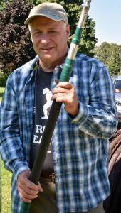
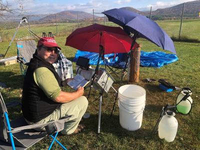
Figure 1. Edwin Romanowicz, Director of the Center for Earth and Environmental Science and Professor of Geology at the SUNY at Plattsburgh.
Figure 2. Jon Kim, geologist at the Vermont Geological Survey.
In order to log a well, the pump, hose, and wiring need to be removed beforehand and coiled onto a tarp on the ground (Figure 3), so as not to interfere with the logging cable and equipment; this equipment is replaced after logging. All geophysical tools are cleansed first with dilute detergent and bottled water (Figure 4) before being sequentially lowered down the well in the following order (Figure 5): A) Borehole Camera, B) Fluid temperature and Conductivity, C) Gamma (natural radioactivity), D) Caliper (well diameter), 4) Acoustic Borehole Imager (ABI) (3D radar image), and 5) Heat Pulse Flowmeter (HPF) (groundwater flow direction and rate) (Figure 5). A dedicated cable reel and tripod were used to lower and retrieve each tool and all data were recorded on a laptop in the field using Mt Sopris™ software (Figure 6). The geophysical logging data sets for all 51 wells are available through the web map and data table below.
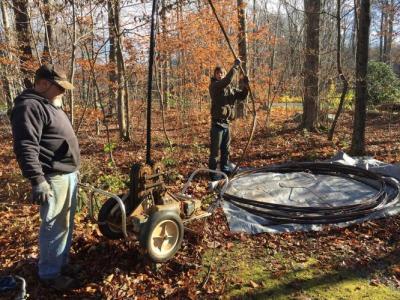
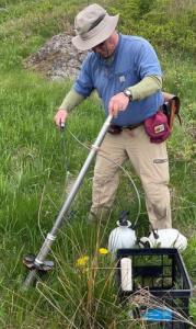
Figure 3. Pulling the pump from a well in Bennington.
Figure 4. Cleaning a logging tool in East Berkshire.
Figure 5. Geophysical logging tools A. GeoVision™ borehole camera; B. Fluid Temperature and Conductivity; C. Gamma; D. Caliper; E. Acoustic Borehole Imager (ABI); F. Heat Pulse Flowmeter (HPF).
Figure 6. Logging a well on the east side of the Rutland Southern Vermont Regional Airport (RSVRA), a site with widespread PFAS contamination of groundwater.
Web map dashboard
To view well logs, use the interactive map dashboard below. Or click here to open dashboard in a new full-screen window.
VGS Work Supported by Geophysical Logging
Kim J.J., Ryan, P.C., Schroeder T., Romanowicz E., Boutt, D., Belaval, M. and Shanley, J., 2023, Four-dimensional characterization of a PFOA-contaminated fractured rock aquifer (FRA) in Bennington, Vermont, U.S.A. Frontiers in Water 5:1117780. https://doi.org/10.3389/frwa.2023.1117780.
Kim, J., Klepeis, K., Ryan, P., Romanowicz, E., Boyles, J., and DeJong, B., 2022, A Conceptual Site Model for the PFAS-Contaminated Fractured Rock Aquifer Beneath the Rutland- Southern Vermont Regional Airport (RSVRA), Vermont: Vermont Geological Survey Technical Report. VGTR2022-2.
Kim, J. J., and Dowey, C. W., 2017, Derivative maps generated from water well data logs in the Bennington area, Vermont: Vermont Geological Survey Open File Report VG2017-3, 4 Plates, scale 1:12,000. Plate 1. Plate 2. Plate 3. Plate 4.
Kim, J.J., Comstock, J., Ryan, P.C., Heindel, C., and Koenigsberger, S., 2016, Denitrification and dilution along fracture flowpaths influence the recovery of a bedrock aquifer from nitrate contamination: Science of the Total Environment 569-570, p. 450-468. https://doi.org/10.1016/j.scitotenv.2016.06.091.
Kim, J., Klepeis, K., Ryan, P., and Romanowicz, E., 2015, Current Research in Structure, Stratigraphy, and Hydrogeology in the Champlain Valley Belt of West-Central Vermont: in Franzi, D., editor, Geology of the Northeastern Adirondack Mountains and Champlain-St. Lawrence Lowlands of New York, Vermont, and Quebec, New York State Geological Association 87th Annual Meeting, SUNY at Plattsburgh, p. 60-97. PDF.
Bachman, N., Kim, J.J., and Romanowicz, E., 2015, A Geothermal Investigation of 18 Bedrock Wells in Vermont, Vermont Geological Society Technical Report. VGTR2023-1.
Kim, J.J., Ryan, P., Klepeis, K., Gleeson, T., North, K., Davis, L., Bean, and Filoon, J., 2014, Tectonic evolution of a Paleozoic thrust fault influences the hydrogeology of a fractured rock aquifer, northeastern Appalachian foreland: Geofluids. https://doi.org/10.1111/gfl.12076.
Digitized Well Logs Data Files
Links will open in a new window. MP4 videos are available upon request for some well logs.
Data files were created using the attached NGGDPP Borehole Template .xlsx file.
|
Well / Site Name |
Town |
Date Logged |
PDF Links |
WellCad Image Links |
LAS File Links |
Additional Files |
Video available? |
|---|---|---|---|---|---|---|---|
|
East Berkshire |
Berkshire |
11/2/2022 |
Yes |
||||
|
Franklin |
Franklin |
4/28/2022 |
Yes |
||||
|
514OBR-2 |
Bennington |
11/16/2021 |
Yes |
||||
|
Dransfield |
Clarendon |
11/12/2020 |
Yes |
||||
|
VTG |
Clarendon |
10/23/2020 |
Yes |
||||
|
SRE |
Clarendon |
10/9/2020 |
Yes |
||||
|
Rest Area |
Clarendon |
9/11/2019 |
Yes |
||||
|
Thompson |
Clarendon |
9/10/2019 |
Yes |
||||
|
Weeks |
Clarendon |
8/7/2019 |
Yes |
||||
|
AirportNE |
Clarendon |
8/6/2019 |
Yes |
||||
|
379HR |
North Bennington |
9/14/2018 |
Yes |
||||
|
26STL |
Bennington |
9/13/2018 |
Yes |
||||
|
34HR |
Bennington |
9/12/2018 |
Yes |
||||
|
137MD |
Bennington |
11/8/2017 |
Yes |
||||
|
791AHR |
Bennington |
11/7/2017 |
Yes |
||||
|
NBSR |
Bennington |
10/24/2017 |
Yes |
||||
|
447RL |
Bennington |
9/25/2017 |
- |
||||
|
UVM |
Burlington |
5/18/2017 |
- |
||||
|
54CL |
Bennington |
11/29/2016 |
Yes |
||||
|
22STL |
Bennington |
11/16/2016 |
- |
||||
|
27AW |
Bennington |
11/15/2016 |
- |
||||
|
25AW |
Bennington |
11/8/2016 |
- |
||||
|
175MD |
Bennington |
10/19/2016 |
- |
||||
|
1278HR |
Bennington |
10/18/2016 |
- |
||||
|
514OBR |
Bennington |
10/12/2016 |
- |
||||
|
301HR |
Bennington |
10/11/2016 |
- |
||||
|
995OBR |
Bennington |
10/5/2016 |
- |
||||
|
37STL |
Bennington |
10/4/2016 |
- |
||||
|
Hinesburg Test Well #1 |
Hinesburg |
8/26/2015 |
- |
||||
|
Hinesburg Test Well #2 |
Hinesburg |
10/13/2015 |
- |
||||
|
Ascutney (38487) |
Windsor |
6/19/2015 |
- |
||||
|
39584 |
Milton |
11/25/2014 |
- |
||||
|
48477 |
Hinesburg |
5/21/2014 |
- |
||||
|
8608 |
Hinesburg |
12/2/2013 |
- |
||||
|
High Gates Spring (48210) |
Highgate |
11/18/2013 |
- |
||||
|
7826 |
Hinesburg |
10/15/2013 |
- |
||||
|
GP-01 |
Hinesburg |
10/11/2013 |
- |
||||
|
Jay Peak Well 12 |
Jay |
10/9/2013 |
- |
||||
|
Jay Peak Well 13 |
Jay |
10/9/2013 |
- |
||||
|
Berlin D (082113) |
Berlin |
8/21/2013 |
- |
||||
|
Norland |
Starksboro |
8/20/2013 |
- |
||||
|
Berlin C (39262) |
Berlin |
6/25/2013 |
- |
||||
|
42156 |
Hinesburg |
6/19/2013 |
- |
||||
|
Harwood Union HS Well N (061414) |
Moretown |
6/14/2013 |
- |
||||
|
Harwood Union HS Well O (061313) |
Moretown |
6/13/2013 |
- |
||||
|
Berlin A (053013) |
Berlin |
5/30/2013 |
- |
||||
|
30873 |
Williston |
12/14/2012 |
- |
||||
|
Edgemont |
Killington |
10/26/2012 |
- |
||||
|
Spafford (12984) |
Jericho |
7/25/2012 |
- |
||||
|
Champlain College (42922) |
Burlington |
7/24/2012 |
- |
||||
|
Champlain College (42941) |
Burlington |
7/24/2012 |
- |