The saturated or seasonally saturated conditions in wetlands create an environment that favors the growth of specifically adapted wetland plants (hydrophytic vegetation) and promotes the development of wetland soils (hydric soils). These three factors (hydrology, vegetation, and soils) are used in wetland identification and in the delineation of wetland boundaries. According to Section 3.2 of the Vermont Wetland Rules: "The boundary between a wetland and an upland shall be delineated by the methodology set forth in the 1987 edition of the Corps of Engineers Wetlands Delineation Manual. This methodology employs three parameters: vegetation, soils and hydrology. One function of the Vermont Wetlands Program is to field check delineations made by wetland consultants. The following links will provide more information about wetland delineation in Vermont.
Three Parameters of Wetlands
Hydrology
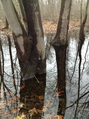
Wetland hydrology refers to the timing and extent of flooding or soil saturation and is considered to be the "driving force" in wetland formation. Rainfall, soil permeability, position in the landscape, surrounding land use, and type of vegetation all influence the hydrology of a wetland. Although hydrology is the most important of the three wetland parameters, it can sometimes be the most difficult factor to determine in the field because water levels in wetlands are often highly variable in the course of an average year.
Hydrophytic Vegetation
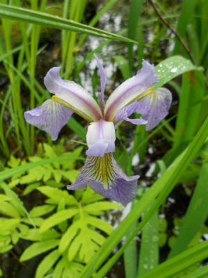
Wetland plants, or hydrophytic "water loving" vegetation, are those plants which have adapted to growing in the low-oxygen (anaerobic) conditions associated with prolonged saturation or flooding. These plants have adapted to anaerobic soil conditions by evolving alternative methods of collecting oxygen such as the enlarged pores (lenticels) in the bark of speckled alder, the hollow stems of rush and grass species, and the air-filled cells (aerenchyma) in the roots of cattails.
Hydric Soils
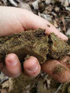
Wetland soil characteristics form when soil is continuously saturated for periods of one or two weeks or more during the growing season. The parent material influences how the soil retains water, and the hydric (wet) soil characteristics that form. The biology of the soil also influences hydric soil characteristics. Under saturated conditions, soil micro-organisms can rapidly use up the oxygen in the soil, which can change its color and appearance.
Links of Interest
- 1987 Corps of Engineers Delineation Manual. The "official" version of the federal manual used in delineations for the Army Corps of Engineers.
- Regional Supplements to the 1987 Wetland Delineation Manual. The Corps has developed supplemental regional criteria for the 1987 Wetland Delineation Manual. The development of Regional Supplements is part of a nationwide effort to address regional wetland characteristics and improve the accuracy and efficiency of wetland-delineation procedures. The Northcentral and Northeast Region Supplement is applicable to Vermont.
- Updated National Wetland Plant List (NWPL). The National Wetlands Plant List is now reviewed and updated on an annual basis. The most current NWPL should be used in any wetland delineations or determinations performed after July 17, 2013. The corresponding NWPL may be used in delineation/determination forms prior to that date, and should be referenced on any data forms used in the wetland delineation/determination if used.
- Field Indicators of Hydric Soils in the United States (PDF, 16.6 MB). A guide for identifying and delineating hydric soils, version 8.1, 2017. A subset of these soils are found in the regional supplement. To use indicators properly, a basic knowledge of soil/landscape relationships is necessary.
- VT Wetland Consultant List. A list of Wetland/Environmental Consultants that perform wetland delineations in Vermont. This list of consultants does not represent an endorsement of the firms by the Wetlands Section nor does it represent a complete list of available consultants.
- ANR Natural Resource Atlas. This web-based mapping tool is designed to help the public locate potential wetlands, based on Vermont Significant Wetlands Inventory (VSWI) data, and other features such as hydric soils and flood hazard zones.