Watershed Planners
 Watershed Planners encourage public involvement and welcome input as they develop the tactical basin plans. Watershed Planners are responsible for river and stream water quality and aquatic habitat assessments, municipal surface water protection assistance, and the Tactical Planning Process. Planners evaluate river and stream problems and threats; identify special uses, values, and characteristics; catalyze and support watershed organizations and projects; provide funding and technical assistance to nonpoint source planning and implementation projects; and provide information and assistance to municipalities for local surface water protection.
Watershed Planner Regions
Click here for a map of Watershed Planner's regions and contact information
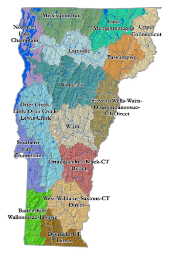
Hudson River Drainage Basin
Basin 1 - Battenkill, Walloomsac, Hoosic
Lake Champlain Drainage Basin
Basins 2 & 4 - Southern Lake Champlain *
Basin 3 - Otter Creek, Little Otter Creek, Lewis Creek
Basin 5 - Northern Lake Champlain
Basin 6 - Missisquoi Bay †
Basin 7 - Lamoille
Basin 8 - Winooski
Connecticut River Drainage Basin
Basin 9 - White
Basin 10 - Ottauquechee, Black ‡
Basin 11 - West, Williams, Saxtons ‡
Basins 12 & 13 - Deerfield ‡
Basin 14 - Stevens, Wells, Waits, Ompompanoosuc §
Basin 15 - Passumpsic
Basin 16 - Upper Connecticut
Lake Memphremagog Drainage Basin
Basin 17 - Lake Memphremagog
* Recently consolidated into one planning basin. Was previously addressed as two separate planning basins: Poultney-Mettawee basin and Lower Lake Champlain drainages.
† Mississqoui Bay planning basin now includes the Rock and Pike Rivers.
‡ Now includes some adjacent CT River direct drainages that were part of the former Basin 13, which is no longer addressed as its own planning basin.
§ Now includes some adjacent CT River direct drainages that were previously addressed as part of the Upper Connecticut River planning basin.